Toggle navigation
LMEC Home
Exhibitions
Georeferencing
Tools for Teachers
Collections
My Favorites
Sign Up / Log In
Search
Search the map portal
Map Collection
Map Collection
Map Sets
Search
Search
Search for
Search In
All Fields
Creator
Title
Subject
Place
Search All Digital Collections
Advanced Search
8708 Results
My Search
Start Over
More Like
commonwealth:td96p834b
Remove constraint More Like: commonwealth:td96p834b
Filter your Search
Place
North and Central America
5,939
United States
4,848
Massachusetts
2,079
Europe
1,396
Suffolk (county)
1,046
Boston
1,019
Canada
462
Asia
438
more
Place
»
Topic
Boston (Mass.)--Maps
586
United States--Maps
282
Real property--Massachusetts--Boston--Maps
175
Massachusetts--Maps
162
Landowners--Massachusetts--Boston--Maps
133
North America--Maps--Early works to 1800
103
New England--Maps
102
Europe--Maps
79
more
Topic
»
Date
Date range begin
–
Date range end
Current results range from
1482
to
2023
View distribution
Creator
United States. Hydrographic Office
595
O.H. Bailey & Co
148
Des Barres, Joseph F. W. (Joseph Frederick Wallet), 1722-1824
123
United States. Post Office Dept
120
Ptolemy, 2nd cent
100
Walling, Henry Francis, 1825-1888
94
Jefferys, Thomas, -1771
88
Geological Survey (U.S.)
86
more
Creator
»
Format
Maps/Atlases
8,648
Manuscripts
217
Prints
56
Books
36
Objects/Artifacts
10
Drawings/Illustrations
8
Posters
5
Georeferenced
Yes
869
No
7,839
Collection
Norman B. Leventhal Map & Education Center Collection
8,695
Boston and New England Maps
2,233
Urban Maps
2,023
Maritime Charts and Atlases
1,084
American Revolutionary War-Era Maps
628
Boston Redevelopment Authority Collection
87
Richard H. Brown Revolutionary War Map Collection at Mount Vernon
5
MacLean Collection Map Library
3
more
Collection
»
Available to use
No known restrictions
8,552
Creative Commons license
55
Search Constraints
Sort by relevance
relevance
title
date (asc)
date (desc)
Number of results to display per page
20 per page
10
per page
20
per page
50
per page
100
per page
View results as:
grid view
map view
Search Results
6541.
Plan of the town of West Roxbury : compiled from various plans and surveys, by order of the selectmen
6542.
Plan of the town, road, and harbour of Chagre ; Plan of Porto Belo
6543.
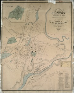
Plan of the towns of Clinton, Worcester Co. Mass : from recent surveys and records
6544.
Plan of the towns of Sturbridge and Southbridge : from actual surveys and records
6545.
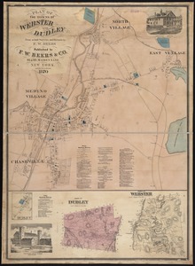
Plan of the towns of Webster and Dudley : from actual surveys and records
6546.
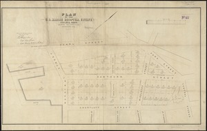
Plan of the U.S. Marine Hospital estate Chelsea, Mass : showing the subdivision into the buildings lots
6547.
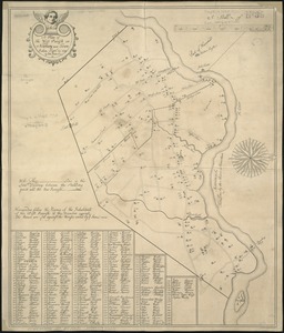
A plan of the west parish or Newbury new town : taken Septs. 15, 1729
6548.
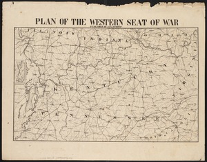
Plan of the western seat of war
6549.
Plan of the yard and buildings of the Manchester Print Works
6550.
A plan of those parts of Boston, and the towns in its vicinity, with the waters and flats adjacent, which are immediately or...
6551.
[Plan of Tremont Street from Park to Boylston]
6552.
[Plan of Tremont Street, from West to Boylston]
6553.
Plan of two lots of valuable land in Washington Village, South Boston : to be sold at Public Auction, on Wednesday April 22d...
6554.
Plan of Waquoit Bay in the town of Falmouth
6555.
Plan of wards 6, 7, 8, 9, 10 and 12, Boston : showing sewers and contours :Jan., 1878
6556.
Plan of Washington Street showing proposed lines of widening from Asylum to Warren : Oct. 2nd 1860
6557.
Plan of Washington Street showing proposed lines of widening from Dover to Asylum : Oct. 3rd 1860
6558.
Plan of Washington Street showing proposed lines of widening from Warren to Kneeland : Oct. 1st 1860
6559.
A plan of West Springfield
6560.
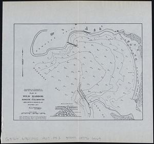
Plan of Wild Harbor at North Falmouth : under chapter 112 resolves of 1907
‹ Prev
Next ›
1
2
…
324
325
326
327
328
329
330
331
332
…
435
436


![[Plan of Tremont Street from Park to Boylston]](https://bpldcassets.blob.core.windows.net/derivatives/images/commonwealth:9s161b59r/image_thumbnail_300.jpg)
![[Plan of Tremont Street, from West to Boylston]](https://bpldcassets.blob.core.windows.net/derivatives/images/commonwealth:sn00b611k/image_thumbnail_300.jpg)