Toggle navigation
LMEC Home
Exhibitions
Georeferencing
Tools for Teachers
Collections
My Favorites
Sign Up / Log In
Search
Search the map portal
Map Collection
Map Collection
Map Sets
Search
Search
Search for
Search In
All Fields
Creator
Title
Subject
Place
Search All Digital Collections
Advanced Search
9088 Results
My Search
Start Over
More Like
commonwealth:t722mh264
Remove constraint More Like: commonwealth:t722mh264
Filter your Search
Place
North and Central America
6,319
United States
5,237
Massachusetts
2,151
Suffolk (county)
1,439
Boston
1,412
Europe
1,396
Canada
449
Asia
438
more
Place
»
Topic
Boston (Mass.)--Maps
685
City planning--Massachusetts--Boston--Maps
418
United States--Maps
282
Real property--Massachusetts--Boston--Maps
253
Urban renewal--Massachusetts--Boston--Maps
253
Landowners--Massachusetts--Boston--Maps
169
Massachusetts--Maps
162
Buildings--Massachusetts--Boston--Maps
124
more
Topic
»
Date
Date range begin
–
Date range end
Current results range from
1482
to
2023
View distribution
Creator
United States. Hydrographic Office
595
Boston Redevelopment Authority
392
O.H. Bailey & Co
148
Des Barres, Joseph F. W. (Joseph Frederick Wallet), 1722-1824
123
United States. Post Office Dept
120
Ptolemy, 2nd cent
100
Walling, Henry Francis, 1825-1888
94
Geological Survey (U.S.)
86
more
Creator
»
Format
Maps/Atlases
9,028
Manuscripts
215
Prints
56
Books
36
Objects/Artifacts
10
Drawings/Illustrations
8
Posters
5
Georeferenced
Yes
869
No
8,219
Collection
Norman B. Leventhal Map & Education Center Collection
8,695
Boston and New England Maps
2,591
Urban Maps
2,379
Maritime Charts and Atlases
1,083
American Revolutionary War-Era Maps
616
Boston Redevelopment Authority Collection
445
Massachusetts Real Estate Atlases
35
Applied Geographics, Inc. Records
1
Available to use
No known restrictions
8,911
Creative Commons license
47
Search Constraints
Sort by relevance
relevance
title
date (asc)
date (desc)
Number of results to display per page
20 per page
10
per page
20
per page
50
per page
100
per page
View results as:
grid view
map view
Search Results
6621.
Plan of boundary line between the Commonwealth of Massachusetts and the State of Connecticut : as located defined and marked by...
6622.
Plan of Briggs Place, in Newton
6623.
Plan of Brighton : reduced from the Ordnance Survey
6624.
Plan of building lots and land in Cambridge & Somerville belonging to Mr. Ozias Morse
6625.
Plan of building lots on the "Kimball" Estate Arlington, Mass. ... at 3 o'clock p.m
6626.
Plan of burnt district by fire of Nov. 9th and 10th, 1872 : showing street improvements as adopted by Board of Street...
6627.
Plan of burnt district, by fire of Nov. 9th and 10th 1872 : showing street improvements as adopted by Board of Street...
6628.
[Plan of channels and flats as they were before the 200 feet outside of the Mill Dam was filled up]
6629.
Plan of Charles River : from the Waltham line to Boston harbor
6630.
Plan of Charles River and Warren bridges, with the vicinity
6631.
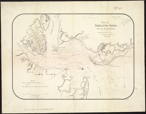
Plan of Charleston Harbor, and its fortifications
6632.
Plan of Charlestown
6633.
Plan of Charlestown
6634.
Plan of Charlestown peninsula in the state of Massachusetts
6635.
Plan of Chestnut Hill, in Brookline & Newton : August 1856
6636.
Plan of Clinton Company's property, "Sawyer's Mills" Boylston, Mass.
6637.
Plan of Coleman's Farm in Newington containing 13 acres - 125 rods
6638.
Plan of cottage lots on Littlejohn's Island, Casco Bay, about 7 1/2 miles northeast of Portland
6639.
Plan of Deer Island
6640.
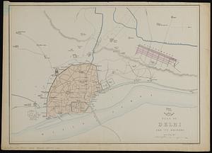
Plan of Delhi and its environs
‹ Prev
Next ›
1
2
…
328
329
330
331
332
333
334
335
336
…
454
455


![[Plan of channels and flats as they were before the 200 feet outside of the Mill Dam was filled up]](https://bpldcassets.blob.core.windows.net/derivatives/images/commonwealth:b8516207x/image_thumbnail_300.jpg)