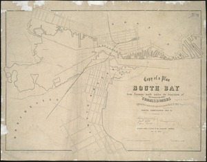
[Plan of channels and flats as they were before the 200 feet outside of the Mill Dam was filled up]
![[Plan of channels and flats as they were before the 200 feet outside of the Mill Dam was filled up]](https://bpldcassets.blob.core.windows.net/derivatives/images/commonwealth:b8516207x/image_access_800.jpg)
Item Information
- Title:
- [Plan of channels and flats as they were before the 200 feet outside of the Mill Dam was filled up]
- Creator:
- Massachusetts. Board of Harbor Commissioners
- Date:
-
[1852]
- Format:
-
Maps/Atlases
- Location:
-
Boston Public Library
Norman B. Leventhal Map & Education Center - Collection (local):
-
Norman B. Leventhal Map & Education Center Collection
- Subjects:
-
Boston (Mass.)--Maps
South Boston (Boston, Mass.)--Maps
Boston Harbor (Mass.)--Maps
- Places:
-
MassachusettsBoston Harbor
MassachusettsSuffolk (county)BostonSouth Boston
- Extent:
- 1 plan ; 45 x 69 cm.
- Terms of Use:
-
No known copyright restrictions.
No known restrictions on use.
- Publisher:
-
Boston :
s.n.
- Scale:
-
Scale: 1:480.
- Language:
-
English
- Notes:
-
Title supplied by cataloger.
Oriented with north toward the upper right.
"Boston, June 19th 1847."
"Boston March 11th 1852, Simon Greenleaf, Joel Giles, Ezra Lincoln, Commissas."
- Notes (date):
-
This date is inferred.
- Identifier:
-
06_01_005003
- Call #:
-
G3762.B65 1852 .B6
- Barcode:
-
39999059009223
 IIIF Manifest