Toggle navigation
LMEC Home
Exhibitions
Georeferencing
Tools for Teachers
Collections
My Favorites
Sign Up / Log In
Search
Search the map portal
Map Collection
Map Collection
Map Sets
Search
Search
Search for
Search In
All Fields
Creator
Title
Subject
Place
Search All Digital Collections
Advanced Search
543 Results
My Search
Start Over
More Like
commonwealth:q524nk40k
Remove constraint More Like: commonwealth:q524nk40k
Filter your Search
Place
North and Central America
438
United States
297
West Indies
59
New York
41
Florida
21
Caribbean Sea
19
Canada
18
Alabama
15
more
Place
»
Topic
Manuscript maps--Early works to 1800
94
West Indies--Maps--Early works to 1800
60
Manuscript maps
21
Caribbean Area--Maps--Early works to 1800
19
Gulf Coast (U.S.)--Maps, Manuscript--Early works to 1800
12
Fortification--New York (State)--New York--Maps--Early works to 1800
11
New York (N.Y.)--Buildings, structures, etc--Maps, Manuscript--Early works to 1800
9
New York (N.Y.)--Maps, Manuscript--Early works to 1800
8
more
Topic
»
Date
Date range begin
–
Date range end
Current results range from
1511
to
1899
View distribution
Creator
Hills, John, (Surveyor)
18
Montrésor, John, 1736-1799
16
Bingham, William, 1752-1804
12
Adlum, John, 1759-1836
10
Washington, George, 1732-1799
9
Faden, William, 1749-1836
7
Morgan, Benjamin, (Draftsman)
7
Wangenheim, Friedrich Adam Julius von
7
more
Creator
»
Format
Maps/Atlases
541
Manuscripts
477
Objects/Artifacts
2
Georeferenced
Yes
17
No
526
Collection
American Revolutionary War-Era Maps
506
Library of Congress Collection
480
Norman B. Leventhal Map Center Collection
55
Maritime Charts and Atlases
44
Urban Maps
15
Richard H. Brown Revolutionary War Map Collection at Mount Vernon
4
Newberry Library Collection
2
New York Public Library Collection
1
more
Collection
»
Available to use
Creative Commons license
485
No known restrictions
55
Search Constraints
Sort by date (desc)
relevance
title
date (asc)
date (desc)
Number of results to display per page
20 per page
10
per page
20
per page
50
per page
100
per page
View results as:
grid view
map view
Search Results
1.
A new general chart of the West Indies from the latest marine journals and surveys regulated and ascertained by astronomical...
2.
The West Indies
3.
The West Indies and coast adjacent : reduced from the sheet map
4.
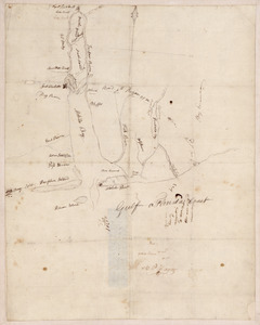
20 tracts, Tioga County
5.
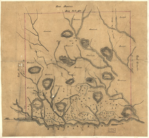
Armstrong C[ount]y
6.
Costa desde la Mobila asta la Bahía de Sn. Josef
7.
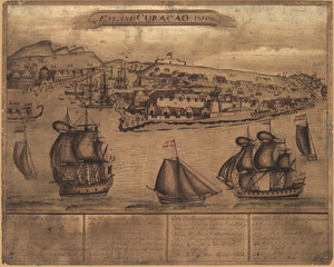
't Eÿland Curacao, anno 1800
8.
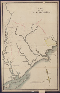
Map of a part of west-Florida : overlay down
9.
Map of a part of west-Florida : overlay up
10.
Map of Las Ormigas Grant, Sabine and DeSoto Parishes, Louisiana
11.
Map of Mobile Bay
12.
Map of the Rigolet and the mouth of the Pearl River, Louisiana and Mississippi
13.
A Map of the Trenton and New-Brunswick Turnpike-road
14.
Plan of part of the city of Washington : on which is shewn the squares, lots, &c., divided between William Prout Esq'r and the...
15.
Plan of Portland
16.
This map of Kentucke
17.
Carta esferica que comprende una parta de las Islas Antillas, las de Puerto Rico, Santo Domingo y Jamayca y Cuba : con los...
18.
Dto de Baton Rouge
19.
Mapa de las locaciones del Distrito de la Na Feliciana
20.
Mapa de las locaciones del Distrito de Manchack
‹ Prev
Next ›
1
2
3
4
5
…
27
28


![Armstrong C[ount]y](https://bpldcassets.blob.core.windows.net/derivatives/images/commonwealth:q524ng353/image_thumbnail_300.jpg)