Toggle navigation
LMEC Home
Exhibitions
Georeferencing
Tools for Teachers
Collections
My Favorites
Sign Up / Log In
Search
Search the map portal
Map Collection
Map Collection
Map Sets
Search
Search
Search for
Search In
All Fields
Creator
Title
Subject
Place
Search All Digital Collections
Advanced Search
560 Results
My Search
Start Over
More Like
commonwealth:q524nc150
Remove constraint More Like: commonwealth:q524nc150
Filter your Search
Place
North and Central America
495
United States
368
Wisconsin
46
New York
40
York (county)
23
Yorktown
23
Canada
19
Florida
19
more
Place
»
Topic
Manuscript maps--Early works to 1800
92
Manuscript maps
84
Yorktown (Va.)--History--Siege, 1781--Maps--Early works to 1800
19
Gulf Coast (U.S.)--Maps, Manuscript--Early works to 1800
12
Fortification--New York (State)--New York--Maps--Early works to 1800
11
New York (N.Y.)--Buildings, structures, etc--Maps, Manuscript--Early works to 1800
9
New York (N.Y.)--Maps, Manuscript--Early works to 1800
8
Saratoga Campaign, N.Y., 1777--Maps, Manuscript--Early works to 1800
8
more
Topic
»
Date
Date range begin
–
Date range end
Current results range from
1620
to
1900
View distribution
Creator
Hills, John, (Surveyor)
18
Montrésor, John, 1736-1799
17
Bingham, William, 1752-1804
12
Washington, George, 1732-1799
11
Adlum, John, 1759-1836
10
Faden, William, 1749-1836
10
Morgan, Benjamin, (Draftsman)
7
Wangenheim, Friedrich Adam Julius von
7
more
Creator
»
Format
Maps/Atlases
557
Manuscripts
539
Objects/Artifacts
2
Prints
1
Georeferenced
Yes
8
No
552
Collection
American Revolutionary War-Era Maps
499
Library of Congress Collection
481
Norman B. Leventhal Map & Education Center Collection
64
Maritime Charts and Atlases
33
Urban Maps
16
Richard H. Brown Revolutionary War Map Collection at Mount Vernon
8
Boston and New England Maps
7
Harvard Map Collection
4
more
Collection
»
Available to use
Creative Commons license
497
No known restrictions
63
Search Constraints
Sort by relevance
relevance
title
date (asc)
date (desc)
Number of results to display per page
20 per page
10
per page
20
per page
50
per page
100
per page
View results as:
grid view
map view
Search Results
281.
Part of New Jersey
282.
Part of Oxford and Cumberland counties, Me
283.
The Part of Pennsylvania that lies between the forks of the Susquehannah, divided into townships
284.
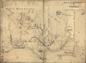
Part of the Province of Virginia
285.
Penobscot River and Bay, with the operations of the English fleet, under Sir George Collyer : against the division of...
286.
Philadelphia and neighborhood
287.
Philadelphia and vicinity. Military
288.
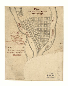
Plan and perspective view of Pittsburgh
289.
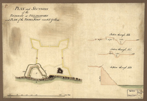
Plan and sections of the redoubt at Billingsfort and plan of the rebel fort marked yellow
290.
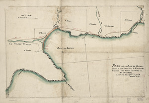
Plan de la Baye de Baynet : situeé a hiut leiues sous le vent de celle de Jacmel, levé suivant les ordres de Mr. d'Estaing le...
291.
Plan de la position de l'armée françoise autour de Newport et du mouillage de l'escadre dans la rade de cette ville
292.
Plan de la retraite de Barren Hill en Pensilvanie : ou un détachement de deux mille deux cent hommes sous le G'al LaFayette...
293.
Plan de la ville de Charlestown, de ses retranchements et du siege faits par les Anglois en 1780
294.
Plan de la ville de Québec
295.
Plan de la ville, du port, et de la rade de New-port et Rhode Island : Debarquement en 1780
296.
Plan de la ville du Trou Jéremie : rélatif à l'article 13 du projet géneral de défense
297.
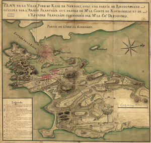
Plan de la ville, port, et rade de Newport : avec une partie de Rhode-Island occupée par l'armée française aux ordres de Mr....
298.
Plan de l'affaire de Westfield & du camp de Raway
299.
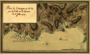
Plan de l'attaque et de la prise de l'isle de la Grenade le 3 juillet 1779
300.
Plan de New-York et des îles environnantes
‹ Prev
Next ›
1
2
…
11
12
13
14
15
16
17
18
19
…
27
28