Toggle navigation
LMEC Home
Exhibitions
Georeferencing
Tools for Teachers
Collections
My Favorites
Sign Up / Log In
Search
Search the map portal
Map Collection
Map Collection
Map Sets
Search
Search
Search for
Search In
All Fields
Creator
Title
Subject
Place
Search All Digital Collections
Advanced Search
480 Results
My Search
Start Over
More Like
commonwealth:q524nc125
Remove constraint More Like: commonwealth:q524nc125
Filter your Search
Place
North and Central America
416
United States
293
New York
40
Florida
19
Canada
17
Alabama
15
Chatham (county)
15
Savannah
13
more
Place
»
Topic
Manuscript maps--Early works to 1800
92
Manuscript maps
21
Gulf Coast (U.S.)--Maps, Manuscript--Early works to 1800
12
Fortification--New York (State)--New York--Maps--Early works to 1800
11
New York (N.Y.)--Buildings, structures, etc--Maps, Manuscript--Early works to 1800
9
New York (N.Y.)--Maps, Manuscript--Early works to 1800
8
Saratoga Campaign, N.Y., 1777--Maps, Manuscript--Early works to 1800
8
Coasts--Florida--Maps--Early works to 1800
7
more
Topic
»
Date
Date range begin
–
Date range end
Current results range from
1700
to
1899
View distribution
Creator
Hills, John, (Surveyor)
18
Montrésor, John, 1736-1799
16
Bingham, William, 1752-1804
12
Adlum, John, 1759-1836
10
Washington, George, 1732-1799
9
Faden, William, 1749-1836
7
Morgan, Benjamin, (Draftsman)
7
Wangenheim, Friedrich Adam Julius von
7
more
Creator
»
Format
Maps/Atlases
478
Manuscripts
475
Objects/Artifacts
2
Georeferenced
Yes
5
No
475
Collection
American Revolutionary War-Era Maps
480
Library of Congress Collection
480
Maritime Charts and Atlases
31
Urban Maps
15
Available to use
Creative Commons license
480
Search Constraints
Sort by date (desc)
relevance
title
date (asc)
date (desc)
Number of results to display per page
20 per page
10
per page
20
per page
50
per page
100
per page
View results as:
grid view
map view
Search Results
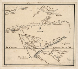
461.
Captain Snow's sketch
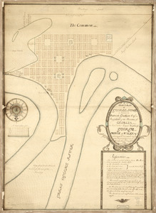
462.
An exact-plan of George-Town : so named by Patrick Graham, Esqr., President of the Province of Georgia, in honr. to His Royal...
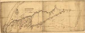
463.
Draft of the lands disputed by Philipse Patent against Beekmans & Rambaults
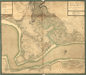
464.
A general plan of Annapolis Royal
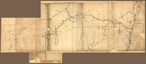
465.
A Map of the western parts of the province of Pennsylvania, Virginia, &c
466.
A trader's map of the Ohio country before 1753
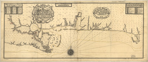
467.
A map of Savannah River beginning at Stone-Bluff, or Nexttobethell, which continueth to the sea : also, the four sounds...
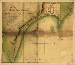
468.
Plan de la ville du Trou Jéremie : rélatif à l'article 13 du projet géneral de défense
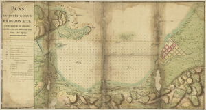
469.
Plan du Petit Goâve et de son acul pour servir au projet général de sa défense par mer en 1752
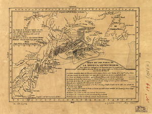
470.
Mapa de una parte de la America Septentrional
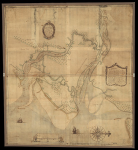
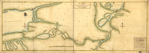
471.
A plan of the inlets & rivers of Savannah & Warsaw in the Province of Georgia
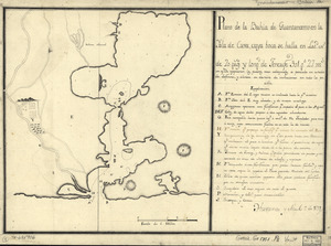
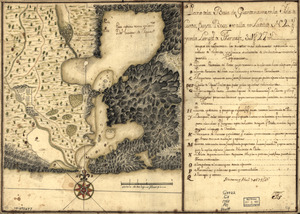
472.
Plano de la bahía de Guantánamo en la ysla de Cuva, cuya boca se halla en latd. N. de 20 gros. y longd. de Tenerife 30l. gs....
473.
Plano de la Baía de Guantánamo, en la ysla de Cuva, cuya boca se alla en latitud N. 20 gs. y en la longitd. de Thenerife 301...
474.
Plano y costa de la Palisada o de Misipipi zituada, su entrada o Cabo de Lodo en 29 gs. 17 ms. de lattud. norte y en longd. de...
475.
A Map of the route from the city of Albany to the Fort Osswego on the Lake of Cataroque
476.
N.W. parts of New York, no. 156
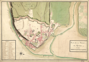
477.
Plan de la ville de Québec
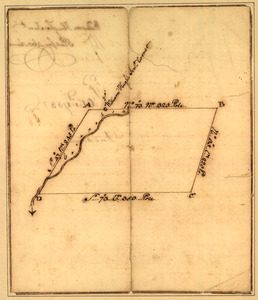
478.
Plat of a survey for William Hughes, Jr. of 460 acres in Frederick County, Va. on the Cacapon River
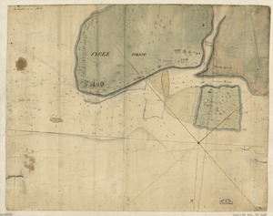
479.
Tybee Island
480.
Cuba, ciudad capittal de la ysla del mismo nombre y su famoso puerto sittuado en la costa del sur de gra. ysla, los 20 grados y...
‹ Prev
Next ›
1
2
…
20
21
22
23
24