Toggle navigation
LMEC Home
Exhibitions
Georeferencing
Tools for Teachers
Collections
My Favorites
Sign Up / Log In
Search
Search the map portal
Map Collection
Map Collection
Map Sets
Search
Search
Search for
Search In
All Fields
Creator
Title
Subject
Place
Search All Digital Collections
Advanced Search
8810 Results
My Search
Start Over
More Like
commonwealth:q524n460c
Remove constraint More Like: commonwealth:q524n460c
Filter your Search
Place
North and Central America
6,011
United States
4,926
Massachusetts
2,079
Europe
1,396
Suffolk (county)
1,046
Boston
1,019
Canada
501
Asia
438
more
Place
»
Topic
Boston (Mass.)--Maps
586
United States--Maps
282
Real property--Massachusetts--Boston--Maps
175
Massachusetts--Maps
162
Landowners--Massachusetts--Boston--Maps
133
North America--Maps--Early works to 1800
110
United States--Maps--Early works to 1800
103
New England--Maps
102
more
Topic
»
Date
Date range begin
–
Date range end
Current results range from
1482
to
2023
View distribution
Creator
United States. Hydrographic Office
595
O.H. Bailey & Co
148
Des Barres, Joseph F. W. (Joseph Frederick Wallet), 1722-1824
123
United States. Post Office Dept
120
Ptolemy, 2nd cent
100
Walling, Henry Francis, 1825-1888
94
Jefferys, Thomas, -1771
87
Geological Survey (U.S.)
86
more
Creator
»
Format
Maps/Atlases
8,750
Manuscripts
217
Prints
56
Books
36
Objects/Artifacts
10
Drawings/Illustrations
8
Posters
5
Georeferenced
Yes
872
No
7,938
Collection
Norman B. Leventhal Map & Education Center Collection
8,696
Boston and New England Maps
2,233
Urban Maps
2,023
Maritime Charts and Atlases
1,083
American Revolutionary War-Era Maps
729
Boston Redevelopment Authority Collection
87
MacLean Collection Map Library
67
New York Public Library Collection
16
more
Collection
»
Available to use
No known restrictions
8,556
Creative Commons license
80
Search Constraints
Sort by relevance
relevance
title
date (asc)
date (desc)
Number of results to display per page
20 per page
10
per page
20
per page
50
per page
100
per page
View results as:
grid view
map view
Search Results
81.
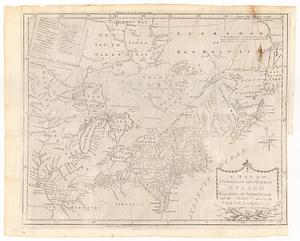
A map of the northern and middle states : comprehending the western territory and the British dominions in North America ;...
82.
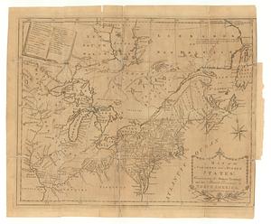
A map of the northern and middle states : comprehending the western territory and the British dominions in North America :...
83.
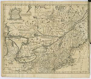
A new and correct map of the provinces of New England, New York, Canada or New France
84.
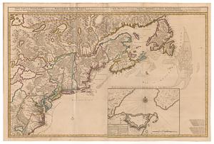
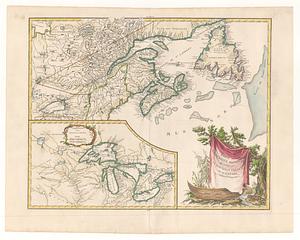
A new map of Nova Scotia and Cape Breton Island : with the adjacent parts of New England and Canada composed from a great...
85.
Nova tabvla geographica complectens borealiorem americæ partem; in qua exacte delineatæ sunt Canada sive Nova Francia, Nova...
86.
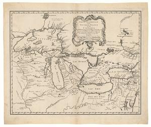
Partie de l'Amerique Septentrionale qui comprend la Nouvelle France ou le Canada
87.
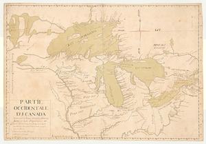
Partie occidentale de la Nouvelle France ou du Canada : pour servir a l'intelligence des affaires et de l"etat present en Amerique
88.
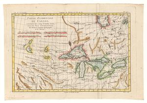
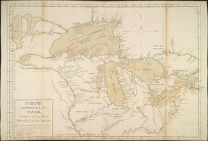
Partie occidentale du Canada, contenant les cinq grands lacs, avec les pays circonvoisins
89.
Partie occidentale du Canada contenant les lacs Ontario, Huron, Erié, et Lac Superieur
90.
Partie occidentale du Canada contenant les Lacs Ontario, Huron, Errie, & Lac Superieur
91.
Partie orientale de la Nouvelle France ou du Canada : avec l'isle de Terre-Neuve et de Nouvelle Escosse, Acadie et Nouv....
92.
Partie orientale de la Nouvelle France ou du Canada
93.
Partie septentrionale des possessions angloise en Amerique
94.
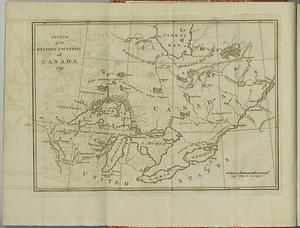
Sketch of the western countries of Canada
95.
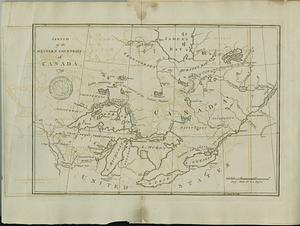
Sketch of the western countries of Canada
96.
Théatre de la guerre en Amerique, avec les Isles Antilles : projetté et assujettie aux observations
97.
Virginia et Nova Francia
98.
An accurate map of the English colonies in North America, bordering on the river Ohio
99.
An accurate map of the United States of America : according to the Treaty of Peace of 1783
100.
L'Amerique Septentrionale, ou se remarquent les Etats Unis
‹ Prev
Next ›
1
2
3
4
5
6
7
8
9
…
440
441