Toggle navigation
LMEC Home
Exhibitions
Georeferencing
Tools for Teachers
Collections
My Favorites
Sign Up / Log In
Search
Search the map portal
Map Collection
Map Collection
Map Sets
Search
Search
Search for
Search In
All Fields
Creator
Title
Subject
Place
Search All Digital Collections
Advanced Search
328 Results
My Search
Start Over
More Like
commonwealth:q524mt75z
Remove constraint More Like: commonwealth:q524mt75z
Filter your Search
Place
North and Central America
261
United States
195
Pennsylvania
39
New York
36
Suffolk (county)
31
Boston
29
Canada
27
North America
27
more
Place
»
Topic
Pennsylvania--Maps--Early works to 1800
37
North America--Maps--Early works to 1800
18
Boston (Mass.)--History--Revolution, 1775-1783--Maps--Early works to 1800
16
New Jersey--Maps--Early works to 1800
12
United States--History--French and Indian War, 1754-1763--Maps--Early works to 1800
10
Vues d'optique
10
Gibraltar--History--Siege, 1779-1783--Maps--Early works to 1800
9
New York (N.Y.)--Pictorial works--Early works to 1800
9
more
Topic
»
Date
Date range begin
–
Date range end
Current results range from
1689
to
1799
View distribution
Creator
Faden, William, 1749-1836
33
Jefferys, Thomas, -1771
31
Le Rouge, Georges-Louis
23
Des Barres, Joseph F. W. (Joseph Frederick Wallet), 1722-1824
22
Sayer, Robert, 1725-1794
21
Korn, Christoph Heinrich, 1726-1783
11
Raspe, Gabriel Nicolaus, 1712-1785
11
Robert Sayer and John Bennett (Firm)
10
more
Creator
»
Format
Maps/Atlases
285
Prints
32
Manuscripts
25
Drawings/Illustrations
9
Books
2
Georeferenced
Yes
14
No
314
Collection
American Revolutionary War-Era Maps
325
Richard H. Brown Revolutionary War Map Collection at Mount Vernon
293
Norman B. Leventhal Map & Education Center Collection
15
MacLean Collection Map Library
12
New York Public Library Collection
5
Boston and New England Maps
4
Maritime Charts and Atlases
3
Urban Maps
3
more
Collection
»
Available to use
Creative Commons license
300
No known restrictions
15
Search Constraints
Sort by relevance
relevance
title
date (asc)
date (desc)
Number of results to display per page
20 per page
10
per page
20
per page
50
per page
100
per page
View results as:
grid view
map view
Search Results
21.
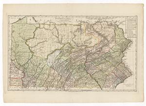
A map of the state of Pennsylvania
22.
A MAPP OF PENSYLVANIA IN AMERICA
23.
A mapp of ye improved part of Pensilvania in America, divided into countyes, townships, and lotts
24.
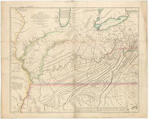
A new and accurate map of the province of Pennsylvania in North America, from the best authorities
25.
A New and accurate map of Virginia : and part of Maryland and Pennsylvania
26.
New Engelland, New York, New Yersey und Pensilvania
27.
A new map of the western parts of Virginia, Pennsylvania, Maryland and North Carolina : comprehending the river Ohio, and all...
28.
A new map of Virginia, Mary-land and the improved parts of Penn-sylvania & New Jersey
29.
Pennsylvania
30.
La Pensilvania, la Nuova York, il Jersey Settentrio[na]le : con la parte occidentale del Connecticut, Massachusset-s-bay e...
31.
Pensylvania Nova Jersey et Nova York cum Regionibus ad Fluvium Delaware in America sitis
32.
A plan of the city and environs of Philadelphia
33.
PLAN OF THE PENINSULA OF CHESOPEAK BAY
34.
Seat of war in the environs of Philadeliphia
35.
Seat of war in the environs of Philadeliphia
36.
The State of Pennsylvania
37.
To the Honourable Thomas Penn and Richard Penn, Esqrs., true & absolute proprietaries & Governours of the Province of...
38.
To the honourable Thomas Penn and Richard Penn esq.rs true & absolute proprietaries & governours of the province of...
39.
Abriss der stadt Gibraltar und der darinn befindlichen festen platze, nebst dem meerbusen von Algesiras
40.
An accurate map of His Majesty's province of New-Hampshire in New England : taken from actual surveys of all the inhabited...
‹ Prev
Next ›
1
2
3
4
5
6
…
16
17


![La Pensilvania, la Nuova York, il Jersey Settentrio[na]le](https://bpldcassets.blob.core.windows.net/derivatives/images/commonwealth:z603vq53g/image_thumbnail_300.jpg)