Toggle navigation
LMEC Home
Exhibitions
Georeferencing
Tools for Teachers
Collections
My Favorites
Sign Up / Log In
Search
Search the map portal
Map Collection
Map Collection
Map Sets
Search
Search
Search for
Search In
All Fields
Creator
Title
Subject
Place
Search All Digital Collections
Advanced Search
8931 Results
My Search
Start Over
More Like
commonwealth:js956k42t
Remove constraint More Like: commonwealth:js956k42t
Filter your Search
Place
North and Central America
6,162
United States
5,066
Massachusetts
2,203
Europe
1,396
Suffolk (county)
1,207
Boston
1,180
Canada
450
Asia
438
more
Place
»
Topic
Boston (Mass.)--Maps
752
United States--Maps
282
Massachusetts--Maps
235
Real property--Massachusetts--Boston--Maps
195
City planning--Massachusetts--Boston--Maps
157
Landowners--Massachusetts--Boston--Maps
142
New England--Maps
106
North America--Maps--Early works to 1800
103
more
Topic
»
Date
Date range begin
–
Date range end
Current results range from
1482
to
2023
View distribution
Creator
United States. Hydrographic Office
595
Boston Redevelopment Authority
162
O.H. Bailey & Co
148
Des Barres, Joseph F. W. (Joseph Frederick Wallet), 1722-1824
124
United States. Post Office Dept
120
Ptolemy, 2nd cent
100
Walling, Henry Francis, 1825-1888
95
Geological Survey (U.S.)
92
more
Creator
»
Format
Maps/Atlases
8,870
Manuscripts
217
Prints
56
Books
36
Objects/Artifacts
10
Drawings/Illustrations
8
Posters
5
Ephemera
1
Georeferenced
Yes
893
No
8,038
Collection
Norman B. Leventhal Map & Education Center Collection
8,764
Boston and New England Maps
2,402
Urban Maps
2,143
Maritime Charts and Atlases
1,083
American Revolutionary War-Era Maps
657
Boston Redevelopment Authority Collection
194
Mapping Boston Collection
22
Applied Geographics, Inc. Records
21
more
Collection
»
Available to use
No known restrictions
8,706
Creative Commons license
73
Search Constraints
Sort by relevance
relevance
title
date (asc)
date (desc)
Number of results to display per page
20 per page
10
per page
20
per page
50
per page
100
per page
View results as:
grid view
map view
Search Results
2701.
Danube to India
2702.
Danubius, fluvius Europae maximus, a fontibus ad ostia, cum omnibus fluminibus, ab utroque latere, in illum defluentibus
2703.
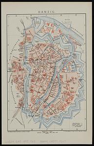
Danzig
2704.
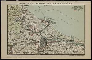
Danzig mit Neufahrwasser und Weichselmünde
2705.
Dawson's map of the Dominion of Canada
2706.
Deans, Krusensterns, and Lazareff Islands
2707.
Deans, Krusensterns, and Lazareff Islands
2708.
Decatur, Ill : 1878
2709.
Decima Asiae tabula
2710.
Decima et ultima Europae tabula
2711.
Decima Europe tabula continent Macedonia et Epirum et Achaiam & Peloponesum
2712.
Deering, Cumberland County, Maine : 1886
2713.
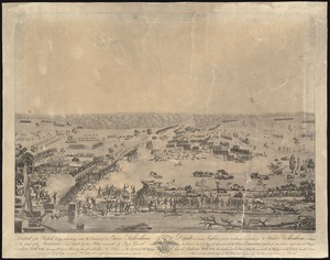
Defeat of the British army 12,000 strong under the command of Sir Edward Packenham in the attack of the American lines defended...
2714.
Delaware
2715.
Delaware and Maryland
2716.
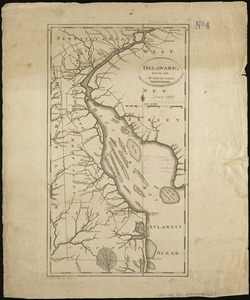
Delaware, from the best authorities
2717.
Delaware, from the best authorities
2718.
Delflandia, Schielandia, et insulae trans Mosam illis objacentes ut sunt Voorna, Overflackea, Goerea, Yselmonda, etc
2719.
Delineatio arcis Cronenburgensis quam sereniss. rex Sueciae amplioribus munimentis cingere fecit A. 1659
2720.
Delineatio eorum quæ d. 10 Nouemb. anno 1658 ad Landscoronam gesta sunt cum Dan Hollandis juncti nauium aliquod demersione...
‹ Prev
Next ›
1
2
…
132
133
134
135
136
137
138
139
140
…
446
447