Toggle navigation
LMEC Home
Exhibitions
Georeferencing
Tools for Teachers
Collections
My Favorites
Sign Up / Log In
Search
Search the map portal
Map Collection
Map Collection
Map Sets
Search
Search
Search for
Search In
All Fields
Creator
Title
Subject
Place
Search All Digital Collections
Advanced Search
9123 Results
My Search
Start Over
More Like
commonwealth:ht250q02z
Remove constraint More Like: commonwealth:ht250q02z
Filter your Search
Place
North and Central America
6,354
United States
5,270
Massachusetts
2,200
Suffolk (county)
1,469
Boston
1,442
Europe
1,396
Canada
449
Asia
438
more
Place
»
Topic
Boston (Mass.)--Maps
752
City planning--Massachusetts--Boston--Maps
418
United States--Maps
282
Urban renewal--Massachusetts--Boston--Maps
252
Real property--Massachusetts--Boston--Maps
225
Massachusetts--Maps
166
Landowners--Massachusetts--Boston--Maps
144
New England--Maps
104
more
Topic
»
Date
Date range begin
–
Date range end
Current results range from
1482
to
2023
View distribution
Creator
United States. Hydrographic Office
595
Boston Redevelopment Authority
398
O.H. Bailey & Co
148
Des Barres, Joseph F. W. (Joseph Frederick Wallet), 1722-1824
124
United States. Post Office Dept
120
Ptolemy, 2nd cent
100
Walling, Henry Francis, 1825-1888
94
Geological Survey (U.S.)
87
more
Creator
»
Format
Maps/Atlases
9,063
Manuscripts
215
Prints
56
Books
36
Objects/Artifacts
10
Drawings/Illustrations
8
Posters
5
Georeferenced
Yes
885
No
8,238
Collection
Norman B. Leventhal Map & Education Center Collection
8,723
Boston and New England Maps
2,619
Urban Maps
2,401
Maritime Charts and Atlases
1,083
American Revolutionary War-Era Maps
638
Boston Redevelopment Authority Collection
453
Mapping Boston Collection
20
Massachusetts Real Estate Atlases
12
more
Collection
»
Available to use
No known restrictions
8,926
Creative Commons license
70
Search Constraints
Sort by relevance
relevance
title
date (asc)
date (desc)
Number of results to display per page
20 per page
10
per page
20
per page
50
per page
100
per page
View results as:
grid view
map view
Search Results
6681.
Plan of an estate in High St. to be sold at auction Sat. May 1st 1847 at 12 o'clock on the premises by Whitwell, Seaver & Co....
6682.
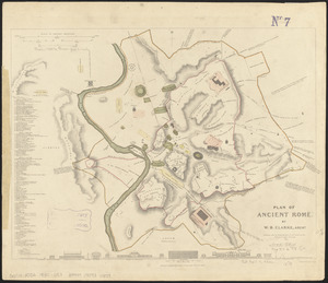
Plan of ancient Rome
6683.
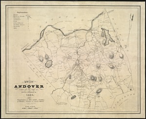
A plan of Andover taken for the town
6684.
Plan of Back Bay showing improvements on streets and estates
6685.
Plan of Bahía Honda ; Plan of Puerto de Cavañas
6686.
Plan of Bahia Xagua on the south side of Cuba ; Plan of the Colorado Rocks, near the west end of Cuba
6687.
A plan of Becket protracted by a scale of 120 rods to an inch
6688.
Plan of Bishop Parker's estate Bedford Street
6689.
Plan of Boston
6690.
Plan of Boston
6691.
A plan of Boston, from actual survey
6692.
A plan of Boston, from actual survey
6693.
Plan of Boston in 1630 and 1900
6694.
A plan of Boston in 1722
6695.
A plan of Boston in New England with its environs : including Milton, Dorchester, Roxbury, Brooklin, Cambridge, Medford,...
6696.
Plan of Boston Land Co's land in Boston & Revere
6697.
[Plan of Boston neck]
6698.
Plan of Boston showing existing ways and owners on December 25, 1630
6699.
Plan of Boston showing existing ways and owners on December 25, 1635
6700.
Plan of Boston showing existing ways and owners on December 25, 1635
‹ Prev
Next ›
1
2
…
331
332
333
334
335
336
337
338
339
…
456
457


![[Plan of Boston neck]](https://bpldcassets.blob.core.windows.net/derivatives/images/commonwealth:9s161g52n/image_thumbnail_300.jpg)


