Toggle navigation
LMEC Home
Exhibitions
Georeferencing
Tools for Teachers
Collections
My Favorites
Sign Up / Log In
Search
Search the map portal
Map Collection
Map Collection
Map Sets
Search
Search
Search for
Search In
All Fields
Creator
Title
Subject
Place
Search All Digital Collections
Advanced Search
8252 Results
My Search
Start Over
More Like
commonwealth:ht24zx67q
Remove constraint More Like: commonwealth:ht24zx67q
Filter your Search
Place
North and Central America
5,001
United States
3,833
Suffolk (county)
1,115
Boston
1,088
Europe
963
Canada
427
Massachusetts
303
France
269
more
Place
»
Topic
Boston (Mass.)--Maps
594
United States--Maps
270
Real property--Massachusetts--Boston--Maps
252
Landowners--Massachusetts--Boston--Maps
169
Massachusetts--Maps
160
City planning--Massachusetts--Boston--Maps
114
North America--Maps--Early works to 1800
103
New England--Maps
99
more
Topic
»
Date
Date range begin
–
Date range end
Current results range from
1482
to
2023
View distribution
Creator
United States. Hydrographic Office
357
O.H. Bailey & Co
148
Des Barres, Joseph F. W. (Joseph Frederick Wallet), 1722-1824
123
United States. Post Office Dept
120
Boston Redevelopment Authority
118
Ptolemy, 2nd cent
100
Walling, Henry Francis, 1825-1888
94
Bromley, George Washington
85
more
Creator
»
Format
Maps/Atlases
8,193
Manuscripts
215
Prints
51
Books
36
Objects/Artifacts
10
Drawings/Illustrations
8
Posters
4
Georeferenced
Yes
869
No
7,383
Collection
Norman B. Leventhal Map Center Collection
8,163
Boston and New England Maps
2,238
Urban Maps
1,979
Maritime Charts and Atlases
750
American Revolutionary War-Era Maps
616
Boston Redevelopment Authority Collection
140
Massachusetts Real Estate Atlases
35
Available to use
No known restrictions
8,076
Creative Commons license
46
Search Constraints
Sort by relevance
relevance
title
date (asc)
date (desc)
Number of results to display per page
50 per page
10
per page
20
per page
50
per page
100
per page
View results as:
grid view
map view
Search Results
1.
Insurance map of Boston : volume 2
2.
Insurance map of Boston : volume 2
3.
Insurance map of Boston vol. 3 (South & East Boston)
4.
Atlas of the city of Boston : Charlestown and East Boston : from actual surveys and official plans
5.
Atlas of the city of Boston : Charlestown and East Boston : from actual surveys and official plans
6.
Atlas of the city of Boston : East Boston : from actual surveys and official plans
7.
Atlas of the city of Boston : East Boston, Mass. : volume nine : from actual surveys and official plans
8.
Atlas of the city of Boston : South & East Boston : volume four
9.
Atlas of the county of Suffolk, Massachusetts : vol. 4th including East Boston, city of Chelsea, Revere and Winthrop : from...
10.
East Boston flood risk
11.
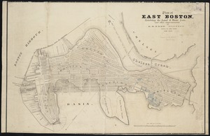
Plan of East Boston : shewing the location of a mill dam and other improvements
12.
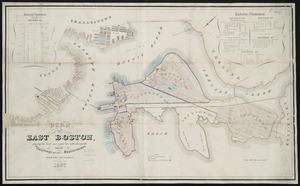
Plan of East Boston showing the land and water lots sold and unsold, also all buildings and other improvements
13.
Plan of sections of 1, 2 & 3, East Boston
14.
Fire insurance district atlas : showing the fire insurance districts of the city of Boston : as established by the State...
15.
Insurance map of Boston : volume 1
16.
Insurance map of Charlestown : portions of Roxbury (now annexed to Boston) and Cambridge : 1868 : corrected Nov. 1871
17.
Insurance map of Charlestown : portions of Roxbury (now annexed to Boston) and Cambridge
18.
Atlas of the city of Boston : East Boston
19.
Atlas of the county of Suffolk, Massachusetts, vol. 4 : including East Boston, city of Chelsea, Revere and Winthrop
20.
A plan of a survey of Noddles Island
21.
Plan of Boston Land Co's land in Boston & Revere
22.
Plan of East Boston : exhibiting the land & water lots and other improvements
23.
Plan of East Boston
24.
Plan of East Boston showing the land and water lots sold and unsold : also all buildings and other improvements
25.
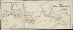
Plan of estate of the Boston Land Co. and surroundings
26.
Plan of Orient Heights, Boston, Mass
27.
Plan of property of the National Dock & Warehouse Co. East Boston
28.
Preliminary plan for Wood Island Park, East Boston
29.
West Wood Island Park, East Boston district
30.
Insurance maps of Boston volume 4 : comprising portions of Charlestown, East Cambridge, Cambridge Port, Old Cambridge & Somerville
31.
Insurance maps of Boston volume one
32.
Insurance maps of Boston volume two
33.
Allston Park, Boston, Mass
34.
Atlas of Dorchester, West Roxbury and Brighton, city of Boston
35.
Atlas of Suffolk, county, vol. 7th, late town of Brighton, now ward 19 of Boston, Massachusetts : from actual survey & official...
36.
Atlas of the city of Boston : Boston proper : from actual surveys and official plans
37.
Atlas of the city of Boston : Boston proper and Back Bay : from actual surveys and official plans
38.
Atlas of the city of Boston : Boston proper and Back Bay : from actual surveys and official plans
39.
Atlas of the city of Boston : Boston proper and Back Bay : from actual surveys and official plans
40.
Atlas of the city of Boston : Boston proper and Back Bay : from actual surveys and official plans
41.
Atlas of the city of Boston : Boston proper and Back Bay : from actual surveys and official plans
42.
Atlas of the city of Boston : Boston proper and Back Bay : from actual surveys and official plans
43.
Atlas of the city of Boston : Boston proper and Back Bay : from actual surveys and official plans
44.
Atlas of the city of Boston : Boston proper and Roxbury : from actual surveys and official plans
45.
Atlas of the city of Boston : Brighton : from actual surveys and official plans
46.
Atlas of the city of Boston : Charlestown : from actual surveys and official plans
47.
Atlas of the city of Boston : Charlestown and Brighton, volume six : from actual surveys and official records
48.
Atlas of the city of Boston : Charlestown, Mass. : volume ten : from actual surveys and official plans
49.
Atlas of the city of Boston : city proper : volume 1 : from actual surveys and official records
50.
Atlas of the city of Boston : city proper and Roxbury : from actual surveys and official plans
‹ Prev
Next ›
1
2
3
4
5
…
165
166