Toggle navigation
LMEC Home
Exhibitions
Georeferencing
Tools for Teachers
Collections
My Favorites
Sign Up / Log In
Search
Search the map portal
Map Collection
Map Collection
Map Sets
Search
Search
Search for
Search In
All Fields
Creator
Title
Subject
Place
Search All Digital Collections
Advanced Search
127 Results
My Search
Start Over
More Like
commonwealth:hq37vv983
Remove constraint More Like: commonwealth:hq37vv983
Filter your Search
Place
North and Central America
84
New Jersey
30
United States
27
New England
23
Massachusetts
20
Connecticut
16
New York
14
Rhode Island
14
more
Place
»
Topic
New Jersey--Maps--Early works to 1800
30
New England--Maps--Early works to 1800
18
Connecticut--Maps--Early works to 1800
15
World maps--Early works to 1800
13
Middle Atlantic States--Maps--Early works to 1800
10
New York (State)--Maps--Early works to 1800
10
Rhode Island--Maps--Early works to 1800
10
America--Maps--Early works to 1800
9
more
Topic
»
Date
Date range begin
–
Date range end
Current results range from
1482
to
1990
View distribution
Creator
Faden, William, 1749-1836
6
Kitchin, Thomas, 1718-1784
5
Ortelius, Abraham, 1527-1598
5
Bancker, Gerard, 1740-1799
4
Lodge, John, -1796
4
Bew, John, -1793
3
Bordon, Benedetto, 1450-1530
3
Gastaldi, Giacomo, approximately 1500-approximately 1565
3
more
Creator
»
Format
Maps/Atlases
127
Books
1
Manuscripts
1
Georeferenced
Yes
15
No
112
Collection
Sidney R. Knafel Map Collection at Phillips Academy
87
American Revolutionary War-Era Maps
59
Norman B. Leventhal Map Center Collection
18
New York Public Library Collection
14
Boston and New England Maps
8
Richard H. Brown Revolutionary War Map Collection at Mount Vernon
7
Library of Congress Collection
1
Maritime Charts and Atlases
1
Available to use
Creative Commons license
22
No known restrictions
18
Search Constraints
Sort by date (asc)
relevance
title
date (asc)
date (desc)
Number of results to display per page
20 per page
10
per page
20
per page
50
per page
100
per page
View results as:
grid view
map view
Search Results
1.
The world
2.
Garden of Eden
3.
Secunda etas mundi = Secunda etas mũdi
4.
Map of the Caribbean Area
5.
World map
6.
Generale Ptholemei
7.
Orbis typus uniuersalis iuxta hydrographorum traditionem
8.
Tipus orbis uniuersalis iuxta Ptolomei cosmographi traditionem et Americi Vespucii alior[um]que
9.
Praeclara Ferna[n]di Cortesii de Noua maris Oceani Hyspania Narratio . . .
10.
Oceani occidetalis seu terre nove tabula
11.
Oval map of the world
12.
Scandinavia
13.
Terra de Lavoratore
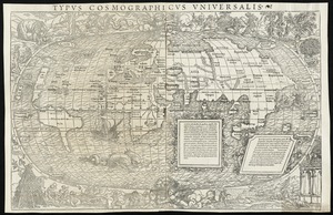
14.
Typus cosmographicus uniuersalis
15.
Nova, et integra universi orbis descriptio
16.
Novae insulae XVII, nova tabula
17.
Carta marina nova tabula
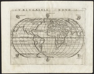
18.
Universale novo
19.
Universalis de terrao orarium ex vera recen [...] traditione
20.
Atlantic Ocean
‹ Prev
Next ›
1
2
3
4
5
6
7


![Tipus orbis uniuersalis iuxta Ptolomei cosmographi traditionem et Americi Vespucii alior[um]que](https://bpldcassets.blob.core.windows.net/derivatives/images/commonwealth:j3860806q/image_thumbnail_300.jpg)
![Praeclara Ferna[n]di Cortesii de Noua maris Oceani Hyspania Narratio . . .](https://bpldcassets.blob.core.windows.net/derivatives/images/commonwealth:zk51wc44m/image_thumbnail_300.jpg)


![Universalis de terrao orarium ex vera recen [...] traditione](https://bpldcassets.blob.core.windows.net/derivatives/images/commonwealth:hq37vv39x/image_thumbnail_300.jpg)
