Toggle navigation
LMEC Home
Exhibitions
Georeferencing
Tools for Teachers
Collections
My Favorites
Sign Up / Log In
Search
Search the map portal
Map Collection
Map Collection
Map Sets
Search
Search
Search for
Search In
All Fields
Creator
Title
Subject
Place
Search All Digital Collections
Advanced Search
8710 Results
My Search
Start Over
More Like
commonwealth:cj82m425c
Remove constraint More Like: commonwealth:cj82m425c
Filter your Search
Place
North and Central America
5,933
United States
4,846
Massachusetts
2,079
Europe
1,396
Suffolk (county)
1,046
Boston
1,019
Canada
449
Asia
438
more
Place
»
Topic
Boston (Mass.)--Maps
586
United States--Maps
282
Real property--Massachusetts--Boston--Maps
175
Massachusetts--Maps
162
Landowners--Massachusetts--Boston--Maps
133
North America--Maps--Early works to 1800
108
New England--Maps
102
Europe--Maps
79
more
Topic
»
Date
Date range begin
–
Date range end
Current results range from
1482
to
2023
View distribution
Creator
United States. Hydrographic Office
595
O.H. Bailey & Co
148
Des Barres, Joseph F. W. (Joseph Frederick Wallet), 1722-1824
123
United States. Post Office Dept
120
Ptolemy, 2nd cent
100
Walling, Henry Francis, 1825-1888
94
Jefferys, Thomas, -1771
89
Geological Survey (U.S.)
86
more
Creator
»
Format
Maps/Atlases
8,650
Manuscripts
219
Prints
56
Books
36
Objects/Artifacts
10
Drawings/Illustrations
8
Posters
5
Georeferenced
Yes
870
No
7,840
Collection
Norman B. Leventhal Map & Education Center Collection
8,694
Boston and New England Maps
2,233
Urban Maps
2,023
Maritime Charts and Atlases
1,083
American Revolutionary War-Era Maps
632
Boston Redevelopment Authority Collection
87
Richard H. Brown Revolutionary War Map Collection at Mount Vernon
8
MacLean Collection Map Library
3
more
Collection
»
Available to use
No known restrictions
8,552
Creative Commons license
57
Search Constraints
Sort by relevance
relevance
title
date (asc)
date (desc)
Number of results to display per page
20 per page
10
per page
20
per page
50
per page
100
per page
View results as:
grid view
map view
Search Results
61.
A new and improved chart of the West India or Carribbee [sic] Islands
62.
A new chart of the Bahama Islands and the Windward Passage
63.
A new chart of the West Indies including the Florida Gulf and Stream
64.
A new general chart of the West Indies from the latest marine journals and srveys regulated and ascertained by astronomical...
65.
A new general chart of the West Indies from the latest marine journals and surveys regulated and ascertained by astronomical...
66.
A new general chart of the West Indies from the latest marine journals and surveys regulated and ascertained by astronomical...
67.
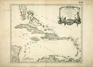
Partie de la mer du Nord, où se trouvent les grandes et petites isles Antilles, et les isles Lucayes
68.
Pascaarte vande vaste cust en eylanden van Westindien, als mede de Virginis en Nieu-Nederland, van C. Droge tot C. Cod
69.
Pascaerte van Brazil en Nieu Nederlandt, van Corvo en Flores tot de Barbados
70.
Pascaerte van Westindien de Vaste Kusten en de Eylanden
71.
Teâtre de la guerre en Amerique telle que'elle est à present possedée par les Espagnols, Anglois, François, et Hollandois...
72.
Terra Firma and the Caribbé Islands &c
73.
The West Indies
74.
West Indies
75.
The West Indies and coast adjacent : reduced from the sheet map
76.
The West Indies exhibiting the English, French, Spanish, Dutch & Danish settlements
77.
West-Indische paskaert : waer in de graden der breedde over weder zyden vande middellyn wassende soo vergroten dat die...
78.
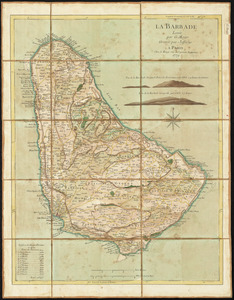
La Barbade
79.
Barbadoes
80.
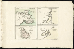
Port, baye cul de sac Royal dans la Martinique -- Isle des Barbades une des Isles Antilles -- Cartagene située sur le Côte de...
‹ Prev
Next ›
1
2
3
4
5
6
7
8
…
435
436
![A new and improved chart of the West India or Carribbee [sic] Islands](https://bpldcassets.blob.core.windows.net/derivatives/images/commonwealth:kk91fq95z/image_thumbnail_300.jpg)