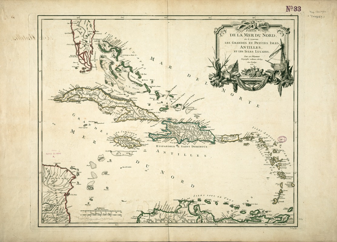
Partie de la mer du Nord, où se trouvent les grandes et petites isles Antilles, et les isles Lucayes
This map is also available in American Revolutionary Geographies Online (ARGO), a collections portal especially built for material relating to the American Revolutionary War Era. Visit ARGO to learn more about this item and explore the historical geography of North America in the late eighteenth century.
Item Information
- Title:
- Partie de la mer du Nord, où se trouvent les grandes et petites isles Antilles, et les isles Lucayes
- Description:
-
This mid-18th-century map by the French royal geographer, Robert de Vaugondy, depicts the West Indies, the chain of islands enclosing the Caribbean Sea. Stretching in an arc from southern Florida to the northern coast of South America, these islands have been divided into three groupings by geographers: the Bahamas (Lucayas), low lying islands east of Florida; the Greater Antilles, including the large mountainous islands of Cuba, Hispaniola, Jamaica, and Puerto Rico; and the Lesser Antilles or Caribbees, small volcanic islands bordering the Caribbean Sea on the east. In comparison to the rest of the Americas, the West Indies were not large in territory, but they were some of Europe's most prized possessions during the 18th century, primarily because of their ability to produce sugar and other tropical plantation crops. In the context of these intense political and commercial rivalries, Robert placed the most prosperous French colony of Saint Domingue (Hispaniola) in the center of the map. He also identified the small islands in the Lesser Antilles with the letters "F", "A", and "D" to indicate French, English, or Danish control. French possessions at this time included Saint Barthľemy, Guadeloupe, Martinique, Saint Lucia, and Grenada.
- Creator:
- Robert de Vaugondy, Gilles, 1688-1766
- Name on Item:
-
par le Sr. Robert ; Guill. ' Delahaye, sculpsit.
- Date:
-
[1750]
- Format:
-
Maps/Atlases
- Location:
-
Boston Public Library
Norman B. Leventhal Map & Education Center - Collection (local):
-
Norman B. Leventhal Map & Education Center Collection
- Subjects:
-
West Indies--Maps--Early works to 1800
- Places:
-
West Indies
- Extent:
- 1 map : col. ; 56 x 79 cm.
- Terms of Use:
-
No known copyright restrictions.
No known restrictions on use.
- Publisher:
-
Paris :
s.n.
- Scale:
-
Scale [ca. 1:750,000].
- Language:
-
French
- Notes:
-
Relief shown pictorially.
Hand colored.
Featured in the Faces & Places Exhibit, Kravis Center, Palm Beach, FL, since 2005. MB (BRL)
Cataloging, conservation, and digitization made possible in part by The National Endowment for the Humanities: Exploring the human endeavor.
- Notes (date):
-
This date is inferred.
- Identifier:
-
05_04_000117
- Call #:
-
G4900 1750 .R61
- Barcode:
-
39999052508007
![[Alleen de Caribische Eilanden, vervat in 't groot]](https://bpldcassets.blob.core.windows.net/derivatives/images/commonwealth:st74cw59p/image_thumbnail_300.jpg)


