Toggle navigation
LMEC Home
Exhibitions
Georeferencing
Tools for Teachers
Collections
My Favorites
Sign Up / Log In
Search
Search the map portal
Map Collection
Map Collection
Map Sets
Search
Search
Search for
Search In
All Fields
Creator
Title
Subject
Place
Search All Digital Collections
Advanced Search
8751 Results
My Search
Start Over
More Like
commonwealth:cj82kr419
Remove constraint More Like: commonwealth:cj82kr419
Filter your Search
Place
North and Central America
5,982
United States
4,890
Massachusetts
2,088
Europe
1,396
Suffolk (county)
1,047
Boston
1,020
Canada
456
Asia
438
more
Place
»
Topic
Boston (Mass.)--Maps
587
United States--Maps
282
Real property--Massachusetts--Boston--Maps
175
Massachusetts--Maps
172
Landowners--Massachusetts--Boston--Maps
133
New England--Maps
111
North America--Maps--Early works to 1800
103
New York (State)--Maps
85
more
Topic
»
Date
Date range begin
–
Date range end
Current results range from
1482
to
2023
View distribution
Creator
United States. Hydrographic Office
595
O.H. Bailey & Co
148
Des Barres, Joseph F. W. (Joseph Frederick Wallet), 1722-1824
123
United States. Post Office Dept
120
Ptolemy, 2nd cent
100
Walling, Henry Francis, 1825-1888
94
Geological Survey (U.S.)
90
Jefferys, Thomas, -1771
85
more
Creator
»
Format
Maps/Atlases
8,691
Manuscripts
217
Prints
56
Books
36
Objects/Artifacts
10
Drawings/Illustrations
8
Posters
5
Georeferenced
Yes
873
No
7,878
Collection
Norman B. Leventhal Map & Education Center Collection
8,701
Boston and New England Maps
2,239
Urban Maps
2,023
Maritime Charts and Atlases
1,083
American Revolutionary War-Era Maps
664
Boston Redevelopment Authority Collection
87
William L. Clements Library Collection
28
American Antiquarian Society Collection
14
more
Collection
»
Available to use
No known restrictions
8,559
Creative Commons license
49
Search Constraints
Sort by relevance
relevance
title
date (asc)
date (desc)
Number of results to display per page
20 per page
10
per page
20
per page
50
per page
100
per page
View results as:
grid view
map view
Search Results
101.
Transportation map of New York
102.
Williams' telegraph and rail road map of the New England states, eastern protion of New York state and Canada : compiled from...
103.
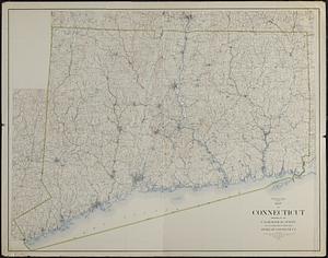
Connecticut from the best authorities
104.
Connecticut from the best authorities
105.
Map of Connecticut
106.
A new and correct map of Connecticut : one of the United States of North America
107.
Open space map of Connecticut, lands dedicated as open space, and selected undeveloped land, lands managed but not dedicated as...
108.
A particular discription of that part of the coast of Connecticut extending from Byram River to Stratford Point : these...
109.
Massachusetts and Rhode Island
110.
Massachusetts and Rhode Island
111.
Partie de l'état de Rhode-Island et position des armées Américaine et Britannique au siege de Newport et à l'affaire du 29 Août...
112.
The State of Rhode Island, : from the latest surveys. 1796
113.
15 lots of 440a each in Great Lot no. 4 of Macomb purchase : 6600 acres within 2 miles of the St. Lawrence Turnpike & 1/2 mile...
114.
1st. sheet of De Witt's state-map of New York
115.
An accurate map of New York in North America from a late survey
116.
Carte de la Nouvelle Angleterre, Nouvelle Yorck, et Pensilvanie. : Pour servir à l'Histoire générale des voyages
117.
A chorographical map of the northern department of North-America : drawn from the latest and most accurate observations
118.
An Exact map of New England, New York, Pensylvania & New Jersey, : from the latest surveys
119.
Four wood lots in no 3
120.
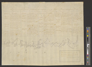
Fragment of map showing two small fortifications
‹ Prev
Next ›
1
2
3
4
5
6
7
8
9
10
…
437
438