Toggle navigation
LMEC Home
Exhibitions
Georeferencing
Tools for Teachers
Collections
My Favorites
Sign Up / Log In
Search
Search the map portal
Map Collection
Map Collection
Map Sets
Search
Search
Search for
Search In
All Fields
Creator
Title
Subject
Place
Search All Digital Collections
Advanced Search
8774 Results
My Search
Start Over
More Like
commonwealth:9s161f90v
Remove constraint More Like: commonwealth:9s161f90v
Filter your Search
Place
North and Central America
6,005
United States
4,922
Massachusetts
2,088
Europe
1,396
Suffolk (county)
1,123
Boston
1,096
Canada
449
Asia
438
more
Place
»
Topic
Boston (Mass.)--Maps
607
United States--Maps
282
Real property--Massachusetts--Boston--Maps
253
Landowners--Massachusetts--Boston--Maps
170
Massachusetts--Maps
163
City planning--Massachusetts--Boston--Maps
108
North America--Maps--Early works to 1800
103
New England--Maps
102
more
Topic
»
Date
Date range begin
–
Date range end
Current results range from
1482
to
2023
View distribution
Creator
United States. Hydrographic Office
595
O.H. Bailey & Co
148
Des Barres, Joseph F. W. (Joseph Frederick Wallet), 1722-1824
123
United States. Post Office Dept
120
Boston Redevelopment Authority
111
Ptolemy, 2nd cent
100
Walling, Henry Francis, 1825-1888
94
Geological Survey (U.S.)
87
more
Creator
»
Format
Maps/Atlases
8,714
Manuscripts
215
Prints
56
Books
36
Objects/Artifacts
10
Drawings/Illustrations
8
Posters
5
Georeferenced
Yes
869
No
7,905
Collection
Norman B. Leventhal Map & Education Center Collection
8,694
Boston and New England Maps
2,275
Urban Maps
2,066
Maritime Charts and Atlases
1,083
American Revolutionary War-Era Maps
615
Boston Redevelopment Authority Collection
130
Massachusetts Real Estate Atlases
37
Applied Geographics, Inc. Records
1
Available to use
No known restrictions
8,595
Creative Commons license
47
Search Constraints
Sort by relevance
relevance
title
date (asc)
date (desc)
Number of results to display per page
20 per page
10
per page
20
per page
50
per page
100
per page
View results as:
grid view
map view
Search Results
41.
A rough and inaccurate sketch of the streets of Boston as they are supposed to have been first laid out & the owners of the...
42.
Trustees' sale : beautiful building lots on Walnut St. and Walnut Avenue, in West Roxbury, containing about 3,126,519 square feet
43.
Atlas of the city of Boston : ward 26 Hyde Park
44.
A land ownership map for the Longwood Medical Area as of January 1980
45.
Land ownership maps for land in the Government Center urban renewal project area
46.
A map of the towns of Dorchester and Milton, 1831
47.
Plan of Milton Cemetery
48.
Capital Park : Hyde Park ... Boston
49.
Hyde Park
50.
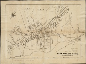
Map of Hyde Park and Vicinity : Norfolk County, Mass
51.
Plan of house lots located on Jamaica Plain belonging to the estate of John Dorr, dec'd
52.
[Plan of lots on West Selden Street, Dorchester]
53.
Atlas of Massachusetts
54.
Allston Park, Boston, Mass
55.
Atlas of Dorchester, West Roxbury and Brighton, city of Boston
56.
Atlas of Suffolk, county, vol. 7th, late town of Brighton, now ward 19 of Boston, Massachusetts : from actual survey & official...
57.
Atlas of the city of Boston : Boston proper : from actual surveys and official plans
58.
Atlas of the city of Boston : Boston proper and Back Bay : from actual surveys and official plans
59.
Atlas of the city of Boston : Boston proper and Back Bay : from actual surveys and official plans
60.
Atlas of the city of Boston : Boston proper and Back Bay : from actual surveys and official plans
‹ Prev
Next ›
1
2
3
4
5
6
7
…
438
439


![[Plan of lots on West Selden Street, Dorchester]](https://bpldcassets.blob.core.windows.net/derivatives/images/commonwealth:js956j14f/image_thumbnail_300.jpg)


