Toggle navigation
LMEC Home
Exhibitions
Georeferencing
Tools for Teachers
Collections
My Favorites
Sign Up / Log In
Search
Search the map portal
Map Collection
Map Collection
Map Sets
Search
Search
Search for
Search In
All Fields
Creator
Title
Subject
Place
Search All Digital Collections
Advanced Search
8920 Results
My Search
Start Over
More Like
commonwealth:9s161c963
Remove constraint More Like: commonwealth:9s161c963
Filter your Search
Place
North and Central America
6,151
United States
5,067
Massachusetts
2,137
Europe
1,396
Suffolk (county)
1,266
Boston
1,239
Canada
449
Asia
438
more
Place
»
Topic
Boston (Mass.)--Maps
752
United States--Maps
282
Real property--Massachusetts--Boston--Maps
253
City planning--Massachusetts--Boston--Maps
187
Landowners--Massachusetts--Boston--Maps
170
Massachusetts--Maps
166
New England--Maps
104
North America--Maps--Early works to 1800
103
more
Topic
»
Date
Date range begin
–
Date range end
Current results range from
1482
to
2023
View distribution
Creator
United States. Hydrographic Office
595
Boston Redevelopment Authority
192
O.H. Bailey & Co
148
Des Barres, Joseph F. W. (Joseph Frederick Wallet), 1722-1824
124
United States. Post Office Dept
120
Ptolemy, 2nd cent
100
Walling, Henry Francis, 1825-1888
94
Geological Survey (U.S.)
87
more
Creator
»
Format
Maps/Atlases
8,860
Manuscripts
215
Prints
56
Books
36
Objects/Artifacts
10
Drawings/Illustrations
8
Posters
5
Georeferenced
Yes
885
No
8,035
Collection
Norman B. Leventhal Map & Education Center Collection
8,724
Boston and New England Maps
2,390
Urban Maps
2,174
Maritime Charts and Atlases
1,083
American Revolutionary War-Era Maps
638
Boston Redevelopment Authority Collection
223
Massachusetts Real Estate Atlases
38
Mapping Boston Collection
20
more
Collection
»
Available to use
No known restrictions
8,697
Creative Commons license
70
Search Constraints
Sort by relevance
relevance
title
date (asc)
date (desc)
Number of results to display per page
20 per page
10
per page
20
per page
50
per page
100
per page
View results as:
grid view
map view
Search Results
5501.
A new and exact map of France divided into all its provinces and acquisitions, according to the newest observations, and that...
5502.
A new and exact map of Spain & Portugal divided into its kingdoms and principalities &c with ye principal roads and...
5503.
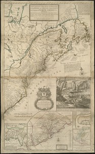
A new and exact map of the dominions of the King of Great Britain on ye continent of North America : containing Newfoundland,...
5504.
A new and exact map of the dominions of the King of Great Britain on ye continent of North America : containing Newfoundland,...
5505.
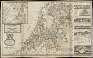
A new and exact map of the United Provinces, or Netherlands &c
5506.
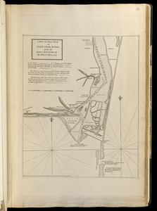
A new and exact plan of Cape Fear River, from the bar to Brunswick
5507.
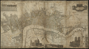
A new and exact plan of the cities of London and Westminster & the borough of Southwark to this present year, exhibiting in a...
5508.
A new and exact plan of the city's of London and Westminster, the borough of Southwark : and the additional new buildings,...
5509.
A new and general map of the middle dominions belonging to the United States of America, viz. Virginia, Maryland, the...
5510.
A new and general map of the Southern dominions belonging to the United States of America, viz North Carolina, South Carolina,...
5511.
A new and improved chart of the West India or Carribbee [sic] Islands
5512.
A new and most exact map of Europe described by N.I. Visscher and don into English and corrected according to I Bleau and...
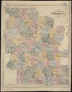
5513.
New bicycle & driving road map of Worcester Co., Massachusetts
5514.
New bond paper map of the city of Washington
5515.
New Brunswick, Nova Scotia, Newfoundland, and Prince Edward Id.
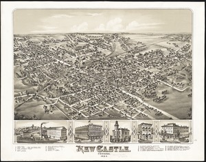
5516.
New Castle, Indiana : 1884
5517.
New chart of Boston Harbor
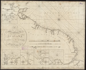
5518.
A new chart of Guyana with the colonies of Cayenne, Surinam, & Trinadad
5519.
A new chart of Massachusetts Bay drawn from the latest authorities
5520.
A new chart of Nantucket Shoals & George's Bank with the adjacent coast
‹ Prev
Next ›
1
2
…
272
273
274
275
276
277
278
279
280
…
445
446

![A new and improved chart of the West India or Carribbee [sic] Islands](https://bpldcassets.blob.core.windows.net/derivatives/images/commonwealth:kk91fq95z/image_thumbnail_300.jpg)