Toggle navigation
LMEC Home
Exhibitions
Georeferencing
Tools for Teachers
Collections
My Favorites
Sign Up / Log In
Search
Search the map portal
Map Collection
Map Collection
Map Sets
Search
Search
Search for
Search In
All Fields
Creator
Title
Subject
Place
Search All Digital Collections
Advanced Search
9003 Results
My Search
Start Over
More Like
commonwealth:8w32tn93q
Remove constraint More Like: commonwealth:8w32tn93q
Filter your Search
Place
North and Central America
6,242
United States
5,161
Massachusetts
2,139
Suffolk (county)
1,397
Europe
1,392
Boston
1,370
Canada
449
Asia
437
more
Place
»
Topic
Boston (Mass.)--Maps
673
City planning--Massachusetts--Boston--Maps
417
United States--Maps
279
Urban renewal--Massachusetts--Boston--Maps
253
Real property--Massachusetts--Boston--Maps
217
Massachusetts--Maps
161
Landowners--Massachusetts--Boston--Maps
135
North America--Maps--Early works to 1800
103
more
Topic
»
Date
Date range begin
–
Date range end
Current results range from
1482
to
2023
View distribution
Creator
United States. Hydrographic Office
595
Boston Redevelopment Authority
393
O.H. Bailey & Co
148
Des Barres, Joseph F. W. (Joseph Frederick Wallet), 1722-1824
123
United States. Post Office Dept
120
Ptolemy, 2nd cent
100
Walling, Henry Francis, 1825-1888
94
Geological Survey (U.S.)
86
more
Creator
»
Format
Maps/Atlases
8,943
Manuscripts
215
Prints
56
Books
36
Objects/Artifacts
10
Drawings/Illustrations
8
Posters
5
Georeferenced
Yes
870
No
8,133
Collection
Norman B. Leventhal Map & Education Center Collection
8,646
Boston and New England Maps
2,577
Urban Maps
2,346
Maritime Charts and Atlases
1,083
American Revolutionary War-Era Maps
615
Boston Redevelopment Authority Collection
443
Available to use
No known restrictions
8,861
Creative Commons license
47
Search Constraints
Sort by relevance
relevance
title
date (asc)
date (desc)
Number of results to display per page
20 per page
10
per page
20
per page
50
per page
100
per page
View results as:
grid view
map view
Search Results
1.
Olmsted Park master plan
2.
Back Bay Fens master plan
3.
James Hayes Park
4.
The Riverway master plan
5.
Back Bay urban renewal area r-47 : existing and proposed community facilities
6.
Charlestown urban renewal area r-42 : GNRP map no. 2
7.
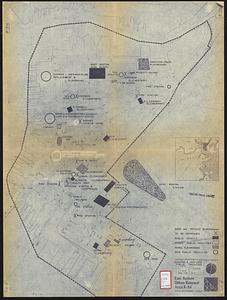
East Boston urban renewal area r-44 : existing & proposed public facilities
8.
Parker Hill-Fenway urban renewal area r-48 : existing and proposed community facilities
9.
Roxbury-N. Dorchester G.N.R.P. r-50 : existing & proposed community facilities
10.
South Boston urban renewal area r-51 : existing and proposed community facilities
11.
South Boston urban renewal area r-51 : existing and proposed public facilities
12.
Jamaica Plain urban renewal area r-49 : building conditions
13.
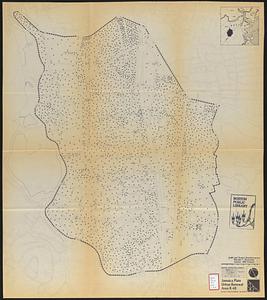
Jamaica Plain urban renewal area r-49 : existing population density
14.
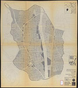
Jamaica Plain urban renewal area r-49 : existing and proposed community facilities
15.
Jamaica Plain urban renewal area r-49 : proposed land use
16.
Jamaica Plain urban renewal area r-49 : existing land use
17.
Jamaica Plain urban renewal area r-49 : proposed circulation
18.
Jamaica Plain urban renewal area r-49 : existing circulation
19.
Jamaica Plain urban renewal area r-49 : proposed treatment and title I projects
20.
Map of Arnold Arboretum showing location of the trees and shrubs
‹ Prev
Next ›
1
2
3
4
5
…
450
451