Back Bay Fens master plan
Item Information
- Title:
- Back Bay Fens master plan
- Contributor:
- Olmsted Historic Landscape Preservation Program (Mass.)
- Contributor:
- Massachusetts. Department of Environmental Management
- Cartographer:
- Pressley Associates
- Cartographer:
- Walmsley & Company
- Name on Item:
-
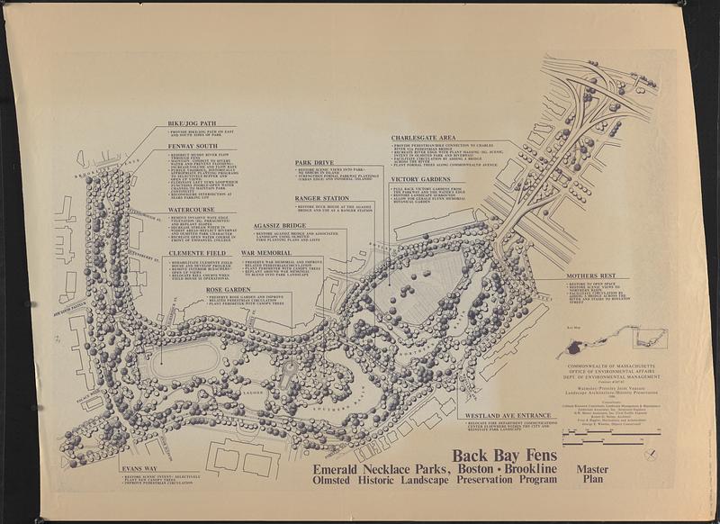
Emerald Necklace Parks, Boston-Brookline, Olmsted Historic Landscape Preservation Program ; Commonwealth of Massachusetts Office of Environmental Affairs Dept. of Environmental Management contract #247-85 ; Walmsley/Pressley joint venture landscape architecture/historic preservation ; consultants Cobham Resource Consultants [and 5 others]
- Date:
-
1986
- Format:
-
Maps/Atlases
- Location:
-
Boston Public Library
Norman B. Leventhal Map & Education Center - Collection (local):
-
Norman B. Leventhal Map & Education Center Collection
- Series:
- Boston Redevelopment Authority Maps & Manuscript Plans Collection
- Subjects:
-
Parks--Massachusetts--Boston--Maps
City planning--Massachusetts--Boston--Maps
Urban renewal--Massachusetts--Boston--Maps
Fenway (Boston, Mass.)--Maps
- Places:
-
MassachusettsSuffolk (county)BostonFens
Back Bay Fens
- Extent:
- 1 map ; 92 x 130 cm, on sheet 108 x 141 cm
- Terms of Use:
-
No known copyright restrictions.
No known restrictions on use.
- Publisher:
-
[Boston] :
[Commonwealth of Massachusetts Dept. of Environmental Management]
- Scale:
-
Scale approximately 1:1,180
- Language:
-
English
- Notes:
-
Shows trees, paths, river, roads and building outlines.
Oriented with north to the upper right.
Includes notes about areas and key map.
- Identifier:
-
06_01_017857
- Call #:
-
BRA MAP FOLDER 32 no.2
- Barcode:
-
30000007747802


