Toggle navigation
LMEC Home
Exhibitions
Georeferencing
Tools for Teachers
Collections
My Favorites
Sign Up / Log In
Search
Search the map portal
Map Collection
Map Collection
Map Sets
Search
Search
Search for
Search In
All Fields
Creator
Title
Subject
Place
Search All Digital Collections
Advanced Search
8577 Results
My Search
Start Over
More Like
commonwealth:8336h284n
Remove constraint More Like: commonwealth:8336h284n
Filter your Search
Place
North and Central America
5,865
United States
4,786
Massachusetts
2,056
Europe
1,359
Suffolk (county)
1,038
Boston
1,011
Canada
448
Asia
422
more
Place
»
Topic
Boston (Mass.)--Maps
580
United States--Maps
278
Real property--Massachusetts--Boston--Maps
175
Massachusetts--Maps
160
Landowners--Massachusetts--Boston--Maps
133
North America--Maps--Early works to 1800
110
New England--Maps
101
Europe--Maps
78
more
Topic
»
Date
Date range begin
–
Date range end
Current results range from
1482
to
2023
View distribution
Creator
United States. Hydrographic Office
594
O.H. Bailey & Co
148
Des Barres, Joseph F. W. (Joseph Frederick Wallet), 1722-1824
123
United States. Post Office Dept
120
Ptolemy, 2nd cent
100
Walling, Henry Francis, 1825-1888
94
Jefferys, Thomas, -1771
87
Geological Survey (U.S.)
86
more
Creator
»
Format
Maps/Atlases
8,518
Manuscripts
218
Prints
56
Books
36
Objects/Artifacts
10
Drawings/Illustrations
8
Posters
4
Georeferenced
Yes
870
No
7,707
Collection
Norman B. Leventhal Map & Education Center Collection
8,566
Boston and New England Maps
2,210
Urban Maps
1,940
Maritime Charts and Atlases
1,081
American Revolutionary War-Era Maps
626
Boston Redevelopment Authority Collection
87
Richard H. Brown Revolutionary War Map Collection at Mount Vernon
6
Newberry Library Collection
2
more
Collection
»
Available to use
No known restrictions
8,424
Creative Commons license
55
Search Constraints
Sort by relevance
relevance
title
date (asc)
date (desc)
Number of results to display per page
20 per page
10
per page
20
per page
50
per page
100
per page
View results as:
grid view
map view
Search Results
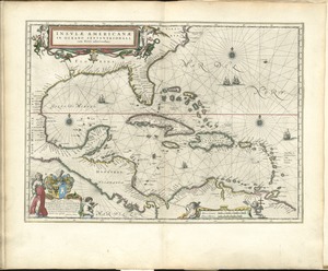
61.
Insulae Americanae in Oceano Septentrionali, cum terris adiacentibus
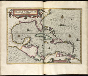
62.
Insulae Americanae in Oceano Septentrionali cum terris adiacentibus
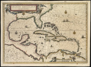
63.
Insulae Americanae in Oceano Septentrionali cum terris adiacentibus
64.
Insulae Americanae in Oceano Septentrionali, cum terris adiacentibus
65.
Les isles Antilles &c. entre lesquelles sont les Lucayes, et les Caribes
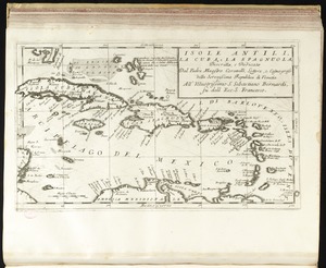
66.
Isole Antili, la Cuba, la Spagnuola
67.
A map of North America, & the West India Islands, with part of South America, Europe, Africa & the Atlantic Ocean with it's...
68.
A map of the British Empire in America with the French and Spanish settlements adjacent thereto
69.
A map of the English, French, Spanish, Dutch, & Danish Islands, in the West Indies, taken from an improved map of the...
70.
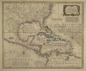
A map of the West-Indies &c. Mexico or New Spain : also ye trade winds, and ye several tracts made by ye galeons and flota from...
71.
A map of the West-Indies or the islands of America in the North Sea : with ye adjacent countries; explaning [sic] what belongs...
72.
A map of the West-Indies or the islands of America in the North Sea : with ye adjacent countries; explaning [sic] what belongs...
73.
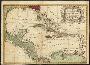
A new & accurate map of the West Indies and the adjacent parts of North & South America
74.
A new and accurate chart of the West Indies : with the adjacent coasts of North and South America
75.
A new and complete map of the West Indies : comprehending all the coasts and islands known by that name
76.
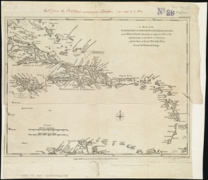
A new and improved chart of the West India or Carribbee [sic] Islands
77.
A new chart of the Bahama Islands and the Windward Passage
78.
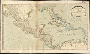
A new chart of the West Indies including the Florida Gulf and Stream
79.
A new general chart of the West Indies from the latest marine journals and srveys regulated and ascertained by astronomical...
80.
A new general chart of the West Indies from the latest marine journals and surveys regulated and ascertained by astronomical...
‹ Prev
Next ›
1
2
3
4
5
6
7
8
…
428
429


![A new and improved chart of the West India or Carribbee [sic] Islands](https://bpldcassets.blob.core.windows.net/derivatives/images/commonwealth:kk91fq95z/image_thumbnail_300.jpg)


