Toggle navigation
LMEC Home
Exhibitions
Georeferencing
Tools for Teachers
Collections
My Favorites
Sign Up / Log In
Search
Search the map portal
Map Collection
Map Collection
Map Sets
Search
Search
Search for
Search In
All Fields
Creator
Title
Subject
Place
Search All Digital Collections
Advanced Search
634 Results
My Search
Start Over
More Like
commonwealth:7h14cw28w
Remove constraint More Like: commonwealth:7h14cw28w
Filter your Search
Place
North and Central America
631
United States
618
Suffolk (county)
431
Boston
429
Massachusetts
319
Roxbury
40
Downtown Boston
38
South End
38
more
Place
»
Topic
City planning--Massachusetts--Boston--Maps
352
Massachusetts--Maps
235
Urban renewal--Massachusetts--Boston--Maps
232
Boston (Mass.)--Maps
153
Land use--Massachusetts--Boston--Maps
97
Buildings--Massachusetts--Boston--Maps
73
Real property--Massachusetts--Boston--Maps
44
Central business districts--Massachusetts--Boston--Maps
40
more
Topic
»
Date
Date range begin
–
Date range end
Current results range from
1760
to
2020
View distribution
Creator
Boston Redevelopment Authority
332
MassGIS (Office : Mass.)
22
Geo. H. Walker & Co
15
Massachusetts. Executive Office of Environmental Affairs
15
Downtown Waterfront Corporation
10
Victor Gruen Associates
10
Boston Public Library. Norman B. Leventhal Map and Education Center
9
Applied Geographics, Inc.
7
more
Creator
»
Format
Maps/Atlases
632
Manuscripts
3
Prints
2
Ephemera
1
Georeferenced
Yes
68
No
566
Collection
Boston and New England Maps
560
Urban Maps
394
Boston Redevelopment Authority Collection
387
Norman B. Leventhal Map & Education Center Collection
220
Applied Geographics, Inc. Records
22
American Revolutionary War-Era Maps
20
David Judkins Weaver Papers
18
Sidney R. Knafel Map Collection at Phillips Academy
8
more
Collection
»
Available to use
No known restrictions
594
Creative Commons license
12
Search Constraints
Sort by relevance
relevance
title
date (asc)
date (desc)
Number of results to display per page
20 per page
10
per page
20
per page
50
per page
100
per page
View results as:
grid view
map view
Search Results
401.
FPIR/FEIR Olmsted Plaza : a redevelopment of the Sears property, 309 Park Drive/201 Brookline Avenue in the Fenway
402.
General plan : Government Center - Boston - 1959
403.
General plan of Franklin Park
404.
Government Center parcel 8 office tower competition program
405.
Government Center project Mass. r-35 : parcel 7 & subway structure topographic map
406.
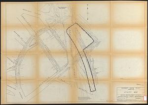
Government Center project Mass. r-35 : utility map
407.
Government Center project Mass. r-35 : property line map
408.
Government Center project no. Mass. r-35 : building deficiencies map
409.
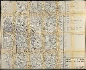
Government Center project no. Mass. r-35 : existing land use map
410.
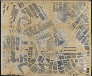
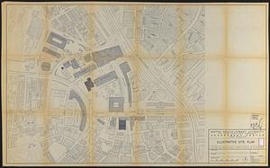
Government Center project no. Mass. r-35 : illustrative site plan
411.
Government Center project no. Mass. r-35 : disposition parcel map
412.
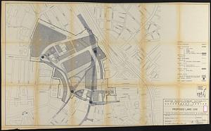
Government Center project no. Mass. r-35 : proposed land use
413.
Government Center project no. Mass. r-35 : proposed land use map
414.
Government Center project no. Mass. r-35 : subway adjustments plan
415.
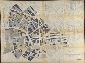
Government Center redevelopment project : land use map
416.
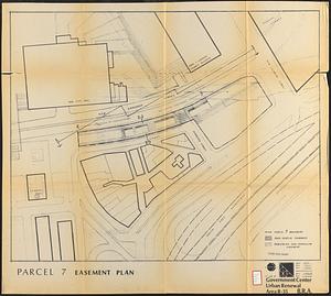
Government Center urban renewal area r-35 : parcel-7 easement plan
417.
Government Center urban renewal area r-35 parcel-7 : site section 1
418.
Government Center urban renewal area r-35 parcel-7 : site section 2
419.
Hancock Woods : as of right plan
420.
Hancock Woods EGA
‹ Prev
Next ›
1
2
…
17
18
19
20
21
22
23
24
25
…
31
32