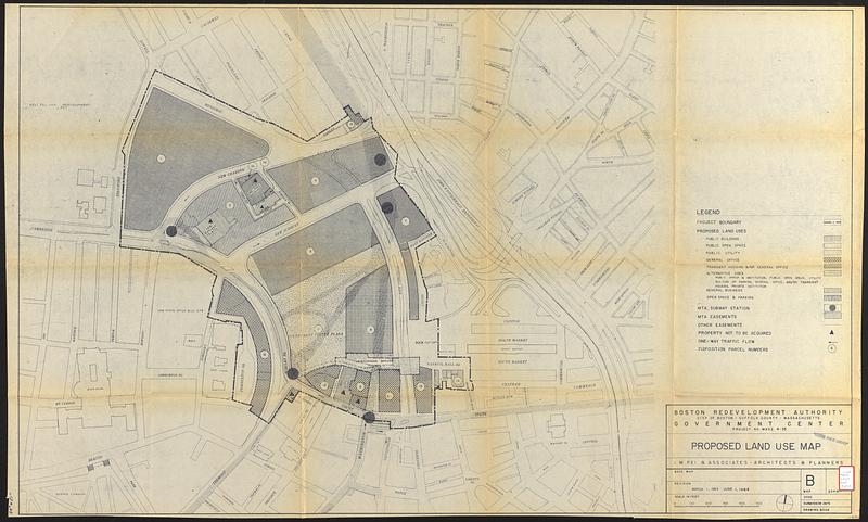
Government Center project no. Mass. r-35 : proposed land use map
Item Information
- Title:
- Government Center project no. Mass. r-35 : proposed land use map
- Cartographer:
- I.M. Pei & Associates
- Publisher:
- Boston Redevelopment Authority
- Name on Item:
-
I.M. Pei & Associates ; Boston Redevelopment Authority
- Date:
-
June 1, 1964
- Format:
-
Maps/Atlases
- Location:
-
Boston Public Library
Central Library in Copley Square - Collection (local):
-
Boston Public Library Collection
- Subjects:
-
Government Center (Boston, Mass.)--Maps
Land use--Massachusetts--Boston--Maps
Subways--Massachusetts--Boston--Maps
Traffic flow--Massachusetts--Boston--Maps
City planning--Massachusetts--Boston--Maps
Urban renewal--Massachusetts--Boston--Maps
Right of way--Massachusetts--Boston--Maps
- Places:
-
Suffolk (county)Boston
Government Center
- Extent:
- 1 map ; 76 x 125 cm
- Terms of Use:
-
No known copyright restrictions.
No known restrictions on use.
- Publisher:
-
[Boston] :
Boston Redevelopment Authority
- Language:
-
English
- Catalog Record:
-
Accompanying text
- Notes:
-
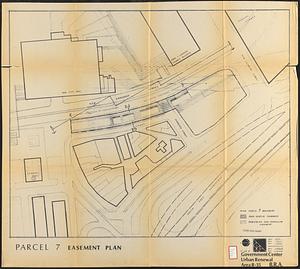
Part of a collection of materials intended to provide prospective developers with information about the Government Center urban renewal project and parcel 7 in downtown Boston.
Shows public buildings, public open space, public utility, general office, transient housing &/or general office, alternative uses, general business, open space & parking, subway stations, MTA easements, other easements, property not to be acquired, one-way traffic flow, and disposition parcel numbers.
- Identifier:
-
06_01_017327c
- Call #:
-
BRA/2997 map 3
- Barcode:
-
39999065832394