Toggle navigation
LMEC Home
Exhibitions
Georeferencing
Tools for Teachers
Collections
My Favorites
Sign Up / Log In
Search
Search the map portal
Map Collection
Map Collection
Map Sets
Search
Search
Search for
Search In
All Fields
Creator
Title
Subject
Place
Search All Digital Collections
Advanced Search
301 Results
My Search
Start Over
More Like
commonwealth:7h149z66c
Remove constraint More Like: commonwealth:7h149z66c
Filter your Search
Place
North and Central America
234
United States
167
New York
31
Suffolk (county)
31
Boston
29
Canada
29
North America
27
Charleston (county)
10
more
Place
»
Topic
North America--Maps--Early works to 1800
18
Boston (Mass.)--History--Revolution, 1775-1783--Maps--Early works to 1800
16
Vues d'optique
10
Gibraltar--History--Siege, 1779-1783--Maps--Early works to 1800
9
New York (N.Y.)--Pictorial works--Early works to 1800
9
United States--History--French and Indian War, 1754-1763--Maps--Early works to 1800
9
United States--Maps--Early works to 1800
9
Boston (Mass.)--Pictorial works--Early works to 1800
8
more
Topic
»
Date
Date range begin
–
Date range end
Current results range from
1740
to
1853
View distribution
Creator
Faden, William, 1749-1836
33
Jefferys, Thomas, -1771
31
Le Rouge, Georges-Louis
23
Des Barres, Joseph F. W. (Joseph Frederick Wallet), 1722-1824
21
Sayer, Robert, 1725-1794
20
Korn, Christoph Heinrich, 1726-1783
11
Raspe, Gabriel Nicolaus, 1712-1785
11
Simcoe, John Graves, 1752-1806
10
more
Creator
»
Format
Maps/Atlases
257
Prints
32
Manuscripts
24
Drawings/Illustrations
9
Books
2
Documents
1
Georeferenced
Yes
13
No
288
Collection
American Revolutionary War-Era Maps
299
Richard H. Brown Revolutionary War Map Collection at Mount Vernon
293
Boston and New England Maps
7
Norman B. Leventhal Map Center Collection
4
Maritime Charts and Atlases
2
Urban Maps
2
American Antiquarian Society Collection
1
Library of Congress Collection
1
more
Collection
»
Available to use
Creative Commons license
294
No known restrictions
5
Search Constraints
Sort by date (asc)
relevance
title
date (asc)
date (desc)
Number of results to display per page
20 per page
10
per page
20
per page
50
per page
100
per page
View results as:
grid view
map view
Search Results
41.
Karte von dem Ostlichen-Stucke von Neu Franckreich oder Canada in America : besonders aber Acadia und Neu Schottland
42.
A general map of North America : in which is express'd the several new roads, forts, engagements, &c, taken from actual surveys...
43.
A new map of North America wherein the British Dominions in the continent of North America : and on the islands of the West...
44.
A south east view of the city of New York, in North America = Vue de sud est de la ville de New York, dans l'Amerique...
45.
A south west view of the city of New York, in North America = Vue de sud ouest de la ville de New York, dans l'Amerique...
46.
Theodolite's pattern, shewing the provinces in North America which were in the respective possessions of England, France &...
47.
Plan de la ville et du port de Boston : capitale de la Nouvelle Angleterre
48.
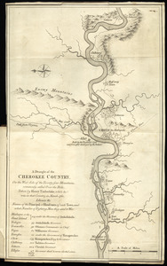
A draught of the Cherokee Country : on the west side of the Twenty Four Mountains, commonly called Over the Hills
49.
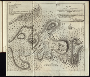
Plan of the battle near Bushy-Run gained by His Majesty's troops commanded by Colonel Henry Bouquet over the Delawares,...
50.
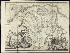
A topographical plan of that part of the Indian-country through which Colonel Bouquet marched in the year, 1764
51.
To the right honourable, the Earl of Shelbourne, His Majesty's principal Secretary of State for the Southern Department : this...
52.
Map of Nova Scotia, or Acadia : with the islands of Cape Breton and St. John's, from actual surveys
53.
A map of the country between Will's Creek & Monongahela River shewing the rout and encampments of the English army in 1755
54.
A map of the most inhabited part of Virginia containing the whole province of Maryland with part of Pensilvania, New Jersey and...
55.
A new map of Nova Scotia, and Cape Britain : with the adjacent parts of New England and Canada, composed from a great number of...
56.
Plan of Fort le Quesne, built by the French at the fork of the Ohio and Monongahela in 1754
57.
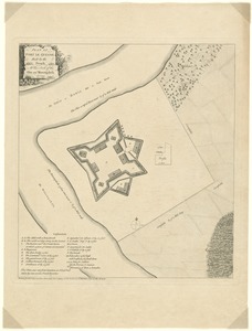
A plan of the city, and fortifications, of Louisburg : from a survey made by Richard Gridley, Lieut. Coll. of the Train of...
58.
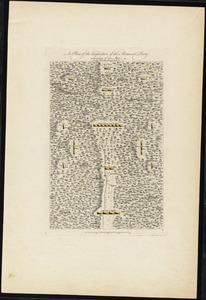
A plan of the disposition of the advanced party consisting of 400 men : to defend the workers in making the road
59.
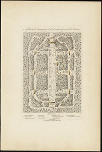
A plan of the encampment of the detachment from the little Meadows
60.
A plan of the field of battle and disposition of the troops, as they were on the march at the time of the attack on the 9th of...
‹ Prev
Next ›
1
2
3
4
5
6
7
…
15
16