Toggle navigation
LMEC Home
Exhibitions
Georeferencing
Tools for Teachers
Collections
My Favorites
Sign Up / Log In
Search
Search the map portal
Map Collection
Map Collection
Map Sets
Search
Search
Search for
Search In
All Fields
Creator
Title
Subject
Place
Search All Digital Collections
Advanced Search
8699 Results
My Search
Start Over
More Like
commonwealth:7h149v69k
Remove constraint More Like: commonwealth:7h149v69k
Filter your Search
Place
North and Central America
5,930
United States
4,844
Massachusetts
2,079
Europe
1,396
Suffolk (county)
1,046
Boston
1,019
Canada
453
Asia
438
more
Place
»
Topic
Boston (Mass.)--Maps
586
United States--Maps
282
Real property--Massachusetts--Boston--Maps
175
Massachusetts--Maps
162
Landowners--Massachusetts--Boston--Maps
133
North America--Maps--Early works to 1800
103
New England--Maps
102
Europe--Maps
79
more
Topic
»
Date
Date range begin
–
Date range end
Current results range from
1482
to
2023
View distribution
Creator
United States. Hydrographic Office
595
O.H. Bailey & Co
148
Des Barres, Joseph F. W. (Joseph Frederick Wallet), 1722-1824
122
United States. Post Office Dept
120
Ptolemy, 2nd cent
100
Walling, Henry Francis, 1825-1888
94
Geological Survey (U.S.)
86
Jefferys, Thomas, -1771
85
more
Creator
»
Format
Maps/Atlases
8,639
Manuscripts
215
Prints
56
Books
36
Objects/Artifacts
10
Drawings/Illustrations
8
Posters
5
Georeferenced
Yes
869
No
7,830
Collection
Norman B. Leventhal Map & Education Center Collection
8,694
Boston and New England Maps
2,233
Urban Maps
2,023
Maritime Charts and Atlases
1,082
American Revolutionary War-Era Maps
620
Boston Redevelopment Authority Collection
87
Library and Archives Canada Collection
4
Richard H. Brown Revolutionary War Map Collection at Mount Vernon
1
Available to use
No known restrictions
8,552
Creative Commons license
48
Search Constraints
Sort by relevance
relevance
title
date (asc)
date (desc)
Number of results to display per page
20 per page
10
per page
20
per page
50
per page
100
per page
View results as:
grid view
map view
Search Results
3641.
Map of Madison and the Four Lake Country, Dane Co. Wis
3642.
Map of Madison County, Virginia : prepared under the direction of P.S. Michie
3643.
Map of Madison, Wisconsin : A.A.A.S. XLII meeting, August 17-24, 1893
3644.
Map of Maine for the Maine register
3645.
Map of Maine, New Hampshire, and Vermont : compiled from the latest authorities
3646.
Map of Maine, New Hampshire and Vermont, from the most authentic sources
3647.
Map of Maine, New Hampshire, Vermont, Massachusetts, Rhode Island, and Connecticut : exhibiting the post offices, post roads,...
3648.
Map of Malta and its dependencies
3649.
Map of Manchuria, Corea & Japan
3650.
Map of maneuver ground, Massachusetts, 1909
3651.
Map of Manitoba
3652.
Map of Manitoba
3653.
Map of Manitoba
3654.
Map of Manitoba, Saskatchewan & Alberta : showing the number of quarter sections available for homestead entry in each...
3655.
Map of Manitoba, Saskatchewan and Alberta : showing the number of quarter sections available for homestead entry in each township
3656.
Map of Manitoba, Saskatchewan and Alberta : showing the number of quarter-sections available for homestead entry in each...
3657.
Map of Manitoba, Saskatchewan and Alberta
3658.
Map of Manitoba shewing provincial government lands for sale
3659.
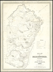
Map of Marshfield, Mass
3660.
A map of Massachusetts
‹ Prev
Next ›
1
2
…
179
180
181
182
183
184
185
186
187
…
434
435