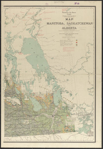
Map of Manitoba, Saskatchewan and Alberta

Item Information
- Title:
- Map of Manitoba, Saskatchewan and Alberta
- Cartographer:
- White, James, 1863-1928
- Contributor:
- Young, R. E. (Robert Evans), 1861-1911
- Publisher:
- Canada. Department of the Interior
- Name on Item:
-
James White, F.R.G.S., geographer ; prepared under the direction of R.E. Young, D.L.S.
- Date:
-
1908
- Format:
-
Maps/Atlases
- Location:
-
Boston Public Library
Norman B. Leventhal Map & Education Center - Collection (local):
-
Norman B. Leventhal Map & Education Center Collection
- Subjects:
-
Land settlement--Prairie Provinces--Maps
Land grants--Prairie Provinces--Maps
Prairie Provinces--Maps
- Places:
-
CanadaProvince of Manitoba (province)
- Extent:
- 1 map on 3 sheets : col. ; 93 x 194 cm. on sheets 104 x 75 cm.
- Terms of Use:
-
No known copyright restrictions.
No known restrictions on use.
- Publisher:
-
[Ottawa] :
Dept. of the Interior
- Edition:
- 6th ed.
- Scale:
-
Scale 1:792,000
- Language:
-
English
- Notes:
-
Relief shown by spot heights.
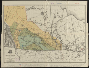
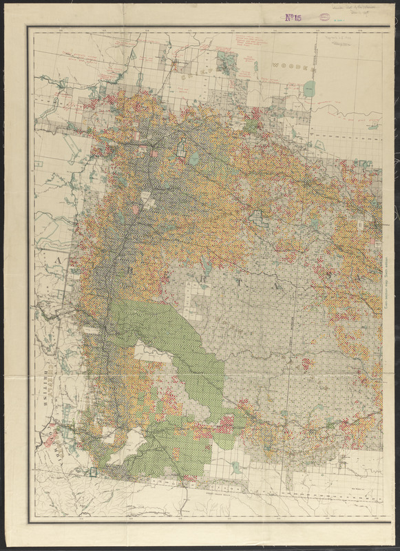
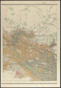
Shows homesteads patented, homesteads unpatented entered prior to 1907, homesteads entered between Jan. 1st 1907 and Jan. 1st 1908, even-numbered sections patented or finally disposed of otherwise than as homesteads, and Indian Reserves surrendered and sold.
"Corrected to Jan. 1st 1908."
"Special edition showing even-numbered sections finally disposed of."
- Identifier:
-
06_01_011583C
06_01_011583B
06_01_011583A
- Call #:
-
G3471.G465 1908 .W45
- Barcode:
-
39999065686121