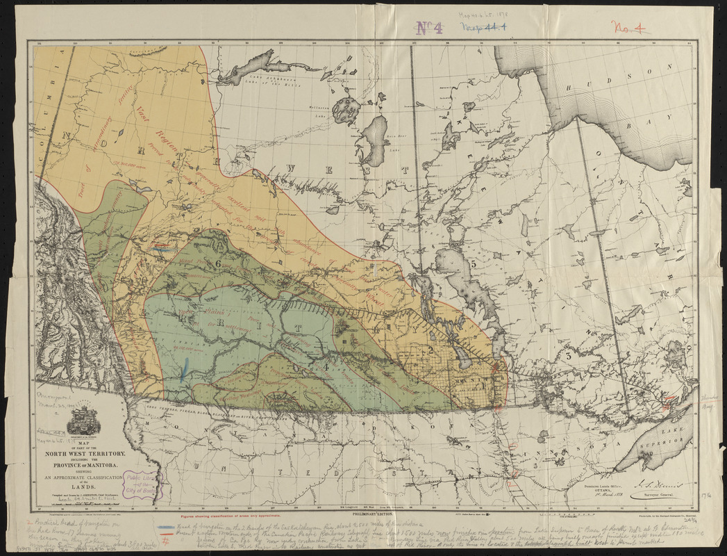
Map of part of the North West Territory, including the province of Manitoba : shewing an approximate classification of the lands
Item Information
- Title:
- Map of part of the North West Territory, including the province of Manitoba : shewing an approximate classification of the lands
- Cartographer:
- Johnston, J.
- Lithographer:
- Burland-Desbarats Company
- Publisher:
- Canada. Department of the Interior
- Name on Item:
-
compiled and drawn by J. Johnston, chief draftsman ; Department of the Interior
- Date:
-
1878
- Format:
-
Maps/Atlases
- Location:
-
Boston Public Library
Norman B. Leventhal Map & Education Center - Collection (local):
-
Norman B. Leventhal Map & Education Center Collection
- Subjects:
-
Soils--Prairie Provinces--Classification--Maps
Land capability for agriculture--Prairie Provinces--Maps
Land capability for agriculture--Alberta--Maps
Land capability for agriculture--Saskatchewan--Maps
Land capability for agriculture--Manitoba--Maps
Prairie Provinces--Maps
Bathymetric maps
- Places:
-
CanadaProvince of Alberta (province)
- Extent:
- 1 map : color ; 44 x 63 cm
- Terms of Use:
-
No known copyright restrictions.
No known restrictions on use.
- Publisher:
-
Ottawa ; Montreal :
Dominion Lands Office ; Burland-Desbarats Co.
- Edition:
- Preliminary edition
- Scale:
-
Scale approximately 1:3,500,000
- Language:
-
English
- Notes:
-
Relief shown by hachures and spot heights.
- Identifier:
-
06_01_014849
- Call #:
-
G3471.J1 1878 .J64
- Barcode:
-
39999065706135