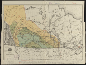
Hydrographic map of Green Lake, Wisconsin

Item Information
- Title:
- Hydrographic map of Green Lake, Wisconsin
- Title (alt.):
-
Hydrographic map of Green Lake, Green Lake County, Wis.
- Surveyor:
- Marsh, C. Dwight (Charles Dwight)
- Surveyor:
- Chandler, Elwyn F. (Elwyn Francis), 1872-1944
- Contributor:
- Birge, E. A. (Edward Asahel), 1851-1950
- Publisher:
- Wisconsin Geological and Natural History Survey
- Name on Item:
-
prepared from surveys by the Wisconsin Geological and Natural History Survey, E.A. Birge, Director ; survey in charge of C. Dwight Marsh ; survey by C. Dwight Marsh and E.F. Chandler
- Date:
-
1899
(created)
(c) 1898 (copyright)
- Format:
-
Maps/Atlases
- Location:
-
Boston Public Library
Norman B. Leventhal Map & Education Center - Collection (local):
-
Norman B. Leventhal Map & Education Center Collection
- Subjects:
-
Hydrology--Wisconsin--Green Lake County--Maps
Green Lake (Green Lake County, Wis. : Lake)--Maps
Bathymetric maps
- Places:
-
WisconsinGreen Lake (county)
Green Lake
- Extent:
- 1 map : color ; 46 x 66 cm, folded in cover 21 x 13 cm
- Terms of Use:
-
No known copyright restrictions.
No known restrictions on use.
- Publisher:
-
Madison, Wisconsin :
Wisconsin Geological and Natural History Survey
- Scale:
-
Scale approximately 1:20,200
- Language:
-
English
- Notes:
-
Also shows roads and hotels.
Depths shown by hypsometric tints, bathymetric isolines and soundings.
"Contour interval = 20 ft."
Includes 5 cross sections.
At head of cover title: no. 7.
Explanation of map on inside of front cover.
Imprint from cover.
- Identifier:
-
06_01_016659
- Call #:
-
G4122.G73C3 1898 .H93
- Barcode:
-
39999085950283