Toggle navigation
LMEC Home
Exhibitions
Georeferencing
Tools for Teachers
Collections
My Favorites
Sign Up / Log In
Search
Search the map portal
Map Collection
Map Collection
Map Sets
Search
Search
Search for
Search In
All Fields
Creator
Title
Subject
Place
Search All Digital Collections
Advanced Search
8552 Results
My Search
Start Over
More Like
commonwealth:6t053r38j
Remove constraint More Like: commonwealth:6t053r38j
Filter your Search
Place
North and Central America
5,846
United States
4,769
Massachusetts
2,052
Europe
1,359
Suffolk (county)
1,034
Boston
1,007
Canada
448
Asia
422
more
Place
»
Topic
Boston (Mass.)--Maps
577
United States--Maps
273
Real property--Massachusetts--Boston--Maps
174
Massachusetts--Maps
160
Landowners--Massachusetts--Boston--Maps
132
North America--Maps--Early works to 1800
103
New England--Maps
99
Europe--Maps
78
more
Topic
»
Date
Date range begin
–
Date range end
Current results range from
1482
to
2023
View distribution
Creator
United States. Hydrographic Office
594
O.H. Bailey & Co
148
Des Barres, Joseph F. W. (Joseph Frederick Wallet), 1722-1824
123
United States. Post Office Dept
120
Ptolemy, 2nd cent
100
Walling, Henry Francis, 1825-1888
94
Geological Survey (U.S.)
86
Jefferys, Thomas, -1771
86
more
Creator
»
Format
Maps/Atlases
8,493
Manuscripts
216
Prints
56
Books
36
Objects/Artifacts
10
Drawings/Illustrations
8
Posters
4
Georeferenced
Yes
869
No
7,683
Collection
Norman B. Leventhal Map & Education Center Collection
8,549
Boston and New England Maps
2,204
Urban Maps
1,936
Maritime Charts and Atlases
1,081
American Revolutionary War-Era Maps
619
Boston Redevelopment Authority Collection
87
Richard H. Brown Revolutionary War Map Collection at Mount Vernon
2
Newberry Library Collection
1
Available to use
No known restrictions
8,408
Creative Commons license
48
Search Constraints
Sort by relevance
relevance
title
date (asc)
date (desc)
Number of results to display per page
20 per page
10
per page
20
per page
50
per page
100
per page
View results as:
grid view
map view
Search Results
3561.
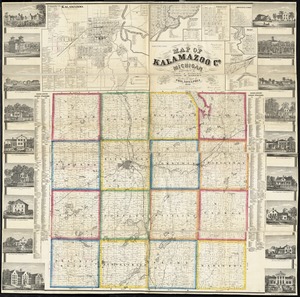
Map of Kalamazoo Co., Michigan
3562.
Map of Keene including the original boundaries of upper Ashuelot
3563.
Map of Kentucky and Tennessee
3564.
Map of Korea
3565.
Map of Korea and Manchuria
3566.
Map of Lake Sunapee and vicinity reached by Boston and Maine Railroad
3567.
A map of Lancaster
3568.
Map of Lapeer Co., Michigan
3569.
Map of Liberia
3570.
A map of Long Island
3571.
A map of Louisiana and of the River Mississipi
3572.
Map of Louisiana, Mississippi and Alabama : constructed from the latest authorities
3573.
Map of Lunenburg
3574.
Map of Lynn and Saugus : settled in 1629
3575.
A map of Mackenzie's track from Fort Chipewyan to the Pacific Ocean in 1793
3576.
Map of Madison and the Four Lake Country, Dane Co. Wis
3577.
Map of Madison County, Virginia : prepared under the direction of P.S. Michie
3578.
Map of Madison, Wisconsin : A.A.A.S. XLII meeting, August 17-24, 1893
3579.
Map of Maine for the Maine register
3580.
Map of Maine, New Hampshire, and Vermont : compiled from the latest authorities
‹ Prev
Next ›
1
2
…
175
176
177
178
179
180
181
182
183
…
427
428