Map of Kalamazoo Co., Michigan
Item Information
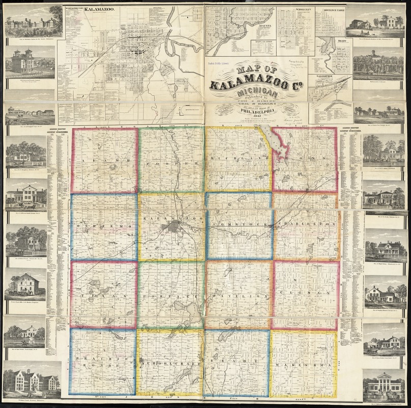
- Title:
- Map of Kalamazoo Co., Michigan
- Creator:
- Geil & Harley
- Name on Item:
-
from special surveys & county records under direction of Geil & Harley, Topographic Engineers ; engd. by Worley & Bracher ; surveyed by I. Gross ; drawn by S. L. Jones, C.E.
- Date:
-
1861
- Format:
-
Maps/Atlases
- Location:
-
Boston Public Library
Norman B. Leventhal Map & Education Center - Collection (local):
-
Norman B. Leventhal Map & Education Center Collection
- Subjects:
-
Buildings--Michigan--Kalamazoo County--Pictorial works
Landowners--Michigan--Kalamazoo County--Maps
Real property--Michigan--Kalamazoo County--Maps
Kalamazoo County (Mich.)--Maps
Augusta (Mich.)--Maps
Galesburg (Mich.)--Maps
Kalamazoo (Mich.)--Maps
Schoolcraft (Mich.)--Maps
Vicksburg (Mich.)--Maps
- Places:
-
MichiganKalamazoo (county)Augusta
MichiganKalamazoo (county)Galesburg
MichiganKalamazoo (county)Kalamazoo
MichiganKalamazoo (county)Schoolcraft
MichiganKalamazoo (county)Vicksburg
- Extent:
- 1 map on 2 sheets : hand colored ; 117 x 117 cm
- Terms of Use:
-
No known copyright restrictions.
No known restrictions on use.
- Publisher:
-
Philadelphia :
Geil & Harley,
- Scale:
-
Scale 1:47,520. 1 1/3 in. to a mile
- Language:
-
English
- Notes:
-
Entered according to Act of Congress in the year 1861 by David S. Harley in the District Court of the district of Michigan.
Includes distance table, business and subscribers' directories, and 18 illustrations of residential, public, and commercial properties.
Insets: Kalamazoo -- Augusta -- Schoolcraft -- Brady -- Galesburgh.
- Identifier:
-
06_01_011170
- Call #:
-
G4113.K2 1861 .G45
- Barcode:
-
39999065682872
- LCCN:
-
2012593151


