Toggle navigation
LMEC Home
Exhibitions
Georeferencing
Tools for Teachers
Collections
My Favorites
Sign Up / Log In
Search
Search the map portal
Map Collection
Map Collection
Map Sets
Search
Search
Search for
Search In
All Fields
Creator
Title
Subject
Place
Search All Digital Collections
Advanced Search
8776 Results
My Search
Start Over
More Like
commonwealth:6t053p36k
Remove constraint More Like: commonwealth:6t053p36k
Filter your Search
Place
North and Central America
6,007
United States
4,917
Massachusetts
2,092
Europe
1,396
Suffolk (county)
1,048
Boston
1,021
Canada
458
Asia
438
more
Place
»
Topic
Boston (Mass.)--Maps
587
United States--Maps
282
Real property--Massachusetts--Boston--Maps
175
Massachusetts--Maps
162
Landowners--Massachusetts--Boston--Maps
133
North America--Maps--Early works to 1800
106
New England--Maps
102
New England--Maps--Early works to 1800
97
more
Topic
»
Date
Date range begin
–
Date range end
Current results range from
1482
to
2023
View distribution
Creator
United States. Hydrographic Office
595
O.H. Bailey & Co
148
Des Barres, Joseph F. W. (Joseph Frederick Wallet), 1722-1824
123
United States. Post Office Dept
120
Ptolemy, 2nd cent
100
Walling, Henry Francis, 1825-1888
94
Jefferys, Thomas, -1771
88
Geological Survey (U.S.)
86
more
Creator
»
Format
Maps/Atlases
8,716
Manuscripts
219
Prints
56
Books
36
Objects/Artifacts
10
Drawings/Illustrations
8
Posters
5
Georeferenced
Yes
876
No
7,900
Collection
Norman B. Leventhal Map & Education Center Collection
8,720
Boston and New England Maps
2,246
Urban Maps
2,023
Maritime Charts and Atlases
1,086
American Revolutionary War-Era Maps
665
Boston Redevelopment Authority Collection
87
Mapping Boston Collection
24
Sidney R. Knafel Map Collection at Phillips Academy
20
more
Collection
»
Available to use
No known restrictions
8,555
Creative Commons license
92
Search Constraints
Sort by relevance
relevance
title
date (asc)
date (desc)
Number of results to display per page
20 per page
10
per page
20
per page
50
per page
100
per page
View results as:
grid view
map view
Search Results
5601.
Northern Mississippi and Alabama
5602.
[Northern Mississippi and Alabama
5603.
Northern New Jersey, showing the iron-ore & limestone districts
5604.
Northern Pacific Rail Road and connections
5605.
Northern part of Florida
5606.
Northern Philippines land utilization
5607.
Northern provinces of the United States
5608.
Northumbria, Cumberlandia, et Dunelmensis Episcopatus
5609.
Northwest Africa
5610.
Northwestern Georgia : (with portions of the adjoining states of Tennessee and Alabama) being part of the Department of the...
5611.
Northwestern part of Lake Huron
5612.
Norton, Massachusetts : 1891
5613.
Norvegia regnum divisum in suos dioeceses Nidrosiensem, Bergensem, Opsloensem, et Stavangriensem et praefecturam Bahusiae quae...
5614.
Norway, from the best authorities
5615.
Norway, west coast : from Norwegian surveys, with corrections to 1886
5616.
Norwood, Massachusetts : 1882
5617.
Noua et accurata totius Americae tabula
5618.
Nouae Africae delineatio
5619.
Nouus planiglobii terrestris per utrumque polum conspectus
5620.
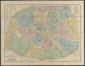
Le nouveau guide de l'étranger dans les 20 arrondissements de Paris
‹ Prev
Next ›
1
2
…
277
278
279
280
281
282
283
284
285
…
438
439