Toggle navigation
LMEC Home
Exhibitions
Georeferencing
Tools for Teachers
Collections
My Favorites
Sign Up / Log In
Search
Search the map portal
Map Collection
Map Collection
Map Sets
Search
Search
Search for
Search In
All Fields
Creator
Title
Subject
Place
Search All Digital Collections
Advanced Search
8798 Results
My Search
Start Over
More Like
commonwealth:6t053p341
Remove constraint More Like: commonwealth:6t053p341
Filter your Search
Place
North and Central America
5,997
United States
4,893
Massachusetts
2,079
Europe
1,396
Suffolk (county)
1,046
Boston
1,019
Canada
472
Asia
438
more
Place
»
Topic
Boston (Mass.)--Maps
586
United States--Maps
330
Real property--Massachusetts--Boston--Maps
175
Massachusetts--Maps
162
Landowners--Massachusetts--Boston--Maps
133
New England--Maps
107
North America--Maps--Early works to 1800
103
North America--Maps
85
more
Topic
»
Date
Date range begin
–
Date range end
Current results range from
1482
to
2023
View distribution
Creator
United States. Hydrographic Office
595
O.H. Bailey & Co
148
Des Barres, Joseph F. W. (Joseph Frederick Wallet), 1722-1824
123
United States. Post Office Dept
120
Ptolemy, 2nd cent
100
Walling, Henry Francis, 1825-1888
94
Geological Survey (U.S.)
87
Jefferys, Thomas, -1771
87
more
Creator
»
Format
Maps/Atlases
8,738
Manuscripts
215
Prints
56
Books
36
Objects/Artifacts
10
Drawings/Illustrations
8
Posters
5
Georeferenced
Yes
874
No
7,924
Collection
Norman B. Leventhal Map & Education Center Collection
8,701
Boston and New England Maps
2,233
Urban Maps
2,023
Maritime Charts and Atlases
1,083
American Revolutionary War-Era Maps
711
Boston Redevelopment Authority Collection
87
American Antiquarian Society Collection
40
William L. Clements Library Collection
31
more
Collection
»
Available to use
No known restrictions
8,557
Creative Commons license
61
Search Constraints
Sort by relevance
relevance
title
date (asc)
date (desc)
Number of results to display per page
20 per page
10
per page
20
per page
50
per page
100
per page
View results as:
grid view
map view
Search Results
41.
Dominion of Canada
42.
E.P. Dutton & Co.'s railroad, steam boat & stage route map of New England, New-York and Canada
43.
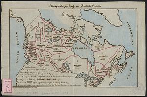
Ethnographische karte von Britisch America : verbreitung der indianer
44.
Government map of part of the Huron and Ottawa Territory, Ontario
45.
A map of Canada
46.
Map of the Dominion of Canada
47.
A map of the province of Upper Canada, describing all the new settlements, townships, & cc. with the countries adjacent, from...
48.
Map shewing the railways of Canada, to accompany annual report on railway statistics 1884
49.
Map showing mounted police stations in north-western Canada
50.
Map to accompany the report on the exploratory survey of the Canadian Pacific Railway
51.
Minerals
52.
New map of the Dominion of Canada
53.
Relief map of the Dominion of Canada
54.
Williams' telegraph and rail road map of the New England states, eastern protion of New York state and Canada : compiled from...
55.
America settle
56.
Amerikanisch-Spanischer kriegsschauplatz
57.
Carta universal en que se contiene todo lo que del mundo se ha descubierto fasta agora
58.
Carte de l'Amérique Septentrionale
59.
Carte du Mexique et des pays limitrophes situés au nord et à l'est : dressée d'après la grande carte de la Nouvelle Espagne...
60.
Illustrated Times map of North America
‹ Prev
Next ›
1
2
3
4
5
6
7
…
439
440