Toggle navigation
LMEC Home
Exhibitions
Georeferencing
Tools for Teachers
Collections
My Favorites
Sign Up / Log In
Search
Search the map portal
Map Collection
Map Collection
Map Sets
Search
Search
Search for
Search In
All Fields
Creator
Title
Subject
Place
Search All Digital Collections
Advanced Search
8269 Results
My Search
Start Over
More Like
commonwealth:6t053n87v
Remove constraint More Like: commonwealth:6t053n87v
Filter your Search
Place
North and Central America
4,934
United States
3,637
Suffolk (county)
1,026
Boston
999
Europe
963
Canada
436
North America
301
France
269
more
Place
»
Topic
Boston (Mass.)--Maps
574
United States--Maps
270
North America--Maps--Early works to 1800
180
Real property--Massachusetts--Boston--Maps
174
Massachusetts--Maps
160
Landowners--Massachusetts--Boston--Maps
132
New England--Maps
99
Europe--Maps
78
more
Topic
»
Date
Date range begin
–
Date range end
Current results range from
1482
to
2023
View distribution
Creator
United States. Hydrographic Office
357
O.H. Bailey & Co
148
Des Barres, Joseph F. W. (Joseph Frederick Wallet), 1722-1824
123
United States. Post Office Dept
120
Ptolemy, 2nd cent
100
Walling, Henry Francis, 1825-1888
94
Jefferys, Thomas, -1771
89
Geological Survey (U.S.)
82
more
Creator
»
Format
Maps/Atlases
8,210
Manuscripts
217
Prints
51
Books
36
Objects/Artifacts
10
Drawings/Illustrations
8
Posters
4
Georeferenced
Yes
874
No
7,395
Collection
Norman B. Leventhal Map Center Collection
8,173
Boston and New England Maps
2,185
Urban Maps
1,925
Maritime Charts and Atlases
750
American Revolutionary War-Era Maps
705
Boston Redevelopment Authority Collection
86
New York Public Library Collection
46
Richard H. Brown Revolutionary War Map Collection at Mount Vernon
26
more
Collection
»
Available to use
No known restrictions
8,026
Creative Commons license
135
Search Constraints
Sort by relevance
relevance
title
date (asc)
date (desc)
Number of results to display per page
20 per page
10
per page
20
per page
50
per page
100
per page
View results as:
grid view
map view
Search Results
161.
A new and correct map of North America : in which the places of the principal engagements during the present war are accurately...
162.
Partie septentrionale des possessions angloise en Amérique : pour servire d'intelligence à la guerre présente entre les...
163.
Schauplatz des Kriegs zwischen Engelland und seinen Collonien in America
164.
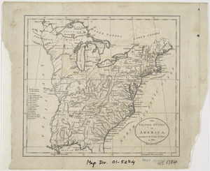
The United States of America, according to the Treaty of Peace of 1784
165.
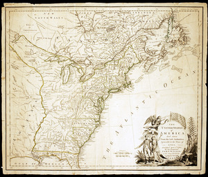
The United States of America laid down from the best authorities, agreeable to the Peace of 1783
166.
The United States of America laid down from the best authorities, agreeable to the Peace of 1783
167.
The United States of America with the British possessions of Canada, Nova Scotia, & of Newfoundland, divided with the French :...
168.
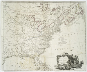
The United States of North America, with the British & Spanish territories according to the treaty
169.
The United States of North America, with the British & Spanish territories according to the treaty
170.
[A map of the east coast of America from Newfoundland to the Bay of Honduras]
171.
An accurate map of North America : Describing and distinguishing the British and Spanish dominions of this great continent;...
172.
An accurate map of North America : describing and distinguishing the British and Spanish dominions on this great continent :...
173.
Acurate charte von Nord-America : aus dem besten quellen
174.
America settentrionale divisa ne' suoi principali stati
175.
America sive novvs orbis respectv Evropaeorvm inferior globi terrestris pars
176.
Americae pars Borealis, Florida, Baccalaos, Canada, Corterealis
177.
L'Amerique divisée en septentrionale et méridionale, subdivisée en ses principales parties, dressée sur les relations les...
178.
L'Amérique septentrionale
179.
Amérique septentrionale avec les routes, distances en miles, limites et etablissements françois et anglois
180.
Amerique septentrionale divisée en ses principales parties
‹ Prev
Next ›
1
2
…
5
6
7
8
9
10
11
12
13
…
413
414


![[A map of the east coast of America from Newfoundland to the Bay of Honduras]](https://bpldcassets.blob.core.windows.net/derivatives/images/commonwealth:hx11z584h/image_thumbnail_300.jpg)


