Toggle navigation
LMEC Home
Exhibitions
Georeferencing
Tools for Teachers
Collections
My Favorites
Sign Up / Log In
Search
Search the map portal
Map Collection
Map Collection
Map Sets
Search
Search
Search for
Search In
All Fields
Creator
Title
Subject
Place
Search All Digital Collections
Advanced Search
8904 Results
My Search
Start Over
More Like
commonwealth:6t053n87v
Remove constraint More Like: commonwealth:6t053n87v
Filter your Search
Place
North and Central America
6,060
United States
4,927
Massachusetts
2,079
Europe
1,396
Suffolk (county)
1,046
Boston
1,019
Canada
472
Asia
441
more
Place
»
Topic
Boston (Mass.)--Maps
586
United States--Maps
282
North America--Maps--Early works to 1800
240
Real property--Massachusetts--Boston--Maps
175
Massachusetts--Maps
162
Landowners--Massachusetts--Boston--Maps
133
United States--Maps--Early works to 1800
103
New England--Maps
102
more
Topic
»
Date
Date range begin
–
Date range end
Current results range from
1482
to
2023
View distribution
Creator
United States. Hydrographic Office
595
O.H. Bailey & Co
148
Des Barres, Joseph F. W. (Joseph Frederick Wallet), 1722-1824
123
United States. Post Office Dept
120
Ptolemy, 2nd cent
100
Jefferys, Thomas, -1771
94
Walling, Henry Francis, 1825-1888
94
Sayer, Robert, 1725-1794
87
more
Creator
»
Format
Maps/Atlases
8,844
Manuscripts
217
Prints
56
Books
36
Objects/Artifacts
10
Drawings/Illustrations
8
Posters
5
Georeferenced
Yes
874
No
8,030
Collection
Norman B. Leventhal Map & Education Center Collection
8,706
Boston and New England Maps
2,234
Urban Maps
2,023
Maritime Charts and Atlases
1,083
American Revolutionary War-Era Maps
808
MacLean Collection Map Library
102
Boston Redevelopment Authority Collection
87
New York Public Library Collection
46
more
Collection
»
Available to use
No known restrictions
8,558
Creative Commons license
136
Search Constraints
Sort by relevance
relevance
title
date (asc)
date (desc)
Number of results to display per page
20 per page
10
per page
20
per page
50
per page
100
per page
View results as:
grid view
map view
Search Results
141.
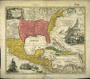
Regni Mexicani seu Novae Hispaniae, Ludovicianae, N. Angliae, Carolinae, Virginae et Pensylvaniae necnon insularum archipelagi...
142.
This map of North America, according to ye newest and most exact observations is most humbly dedicated by your Lordship's most...
143.
Tierra nveva
144.
To the Right Honourable John Lord Sommers, Baron of Evesham in ye county of Worcester, president of Her Majesty's most...
145.
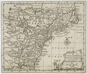
A New & accurate map of North America : including the British acquisitions gained by the late war, 1763
146.
An accurate map of the English colonies in North America, bordering on the river Ohio
147.
An accurate map of the United States of America : according to the Treaty of Peace of 1783
148.
America
149.
British dominions in America agreeable to the treaty of 1763 : divided into the several provinces, and jurisdictions
150.
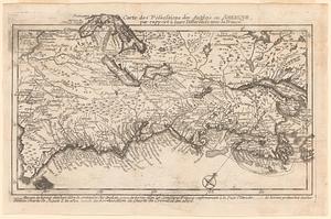
Canada Louisiane et terres angloises
151.
Canada Louisiane et terres angloises
152.
Carta della Nuova Inghilterra, Nuova Iork, e Pensilvania
153.
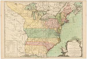
Carte des Etats-Unis d'Amérique, et du cours du Mississipi : redigée d'après différentes cartes et relations anglaises, et les...
154.
Carte des possessions des anglois en Amerique, par rapport à leurs differends avec la France
155.
Carte des pretentions des anglois dans l'Amerique Septentrionale suivant leurs chartres tant sur les possessions de la France...
156.
Carte du Canada et de la Louisiane qui forment la Nouvelle France et des colonies angloises ou sont representez les pays...
157.
Carte du Canada et des Etats-Unis de l'Amérique Septentrionale
158.
Carte du Canada et des Etats-Unis de l'Amerique Septentrionale
159.
Carte du theatre de la guerre presente en Amerique
160.
Carte du theatre de la guerre presente en Amerique
‹ Prev
Next ›
1
2
…
4
5
6
7
8
9
10
11
12
…
445
446