Toggle navigation
LMEC Home
Exhibitions
Georeferencing
Tools for Teachers
Collections
My Favorites
Sign Up / Log In
Search
Search the map portal
Map Collection
Map Collection
Map Sets
Search
Search
Search for
Search In
All Fields
Creator
Title
Subject
Place
Search All Digital Collections
Advanced Search
8868 Results
My Search
Start Over
More Like
commonwealth:4t64k502g
Remove constraint More Like: commonwealth:4t64k502g
Filter your Search
Place
North and Central America
6,099
United States
5,015
Massachusetts
2,139
Europe
1,396
Suffolk (county)
1,214
Boston
1,187
Canada
449
Asia
438
more
Place
»
Topic
Boston (Mass.)--Maps
752
United States--Maps
282
Real property--Massachusetts--Boston--Maps
195
Massachusetts--Maps
166
City planning--Massachusetts--Boston--Maps
162
Landowners--Massachusetts--Boston--Maps
142
New England--Maps
104
North America--Maps--Early works to 1800
103
more
Topic
»
Date
Date range begin
–
Date range end
Current results range from
1482
to
2023
View distribution
Creator
United States. Hydrographic Office
595
Boston Redevelopment Authority
168
O.H. Bailey & Co
148
Des Barres, Joseph F. W. (Joseph Frederick Wallet), 1722-1824
124
United States. Post Office Dept
120
Ptolemy, 2nd cent
100
Walling, Henry Francis, 1825-1888
94
Geological Survey (U.S.)
87
more
Creator
»
Format
Maps/Atlases
8,808
Manuscripts
215
Prints
56
Books
36
Objects/Artifacts
10
Drawings/Illustrations
8
Posters
5
Georeferenced
Yes
885
No
7,983
Collection
Norman B. Leventhal Map & Education Center Collection
8,724
Boston and New England Maps
2,365
Urban Maps
2,148
Maritime Charts and Atlases
1,083
American Revolutionary War-Era Maps
638
Boston Redevelopment Authority Collection
197
Mapping Boston Collection
20
Massachusetts Real Estate Atlases
12
more
Collection
»
Available to use
No known restrictions
8,671
Creative Commons license
70
Search Constraints
Sort by relevance
relevance
title
date (asc)
date (desc)
Number of results to display per page
20 per page
10
per page
20
per page
50
per page
100
per page
View results as:
grid view
map view
Search Results
7341.
La Riviere de la Garomne et la Dordogne et le pays aux environs de Bordeaux
7342.
R.L. Polk & Co.'s map of Bay City, and Essexville Mich
7343.
R.L. Polk & Co's map of greater Battle Creek and suburbs
7344.
R.L. Polk & Co's map of Memphis, Tenn : from official records and original plats
7345.
Road map of the Albany-Troy district
7346.
Road map of the Boston district showing the metropolitan park system.
7347.
Road map of the island of Rhode Island, or Aquidneck
7348.
Road map of Worcester County, Mass
7349.
Roads and communications of Sinkiang
7350.
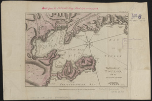
The Roads of Toulon, with the adjacent country
7351.
The roads of ye south part of Great Britain, called England and Wales : Containing all ye cities, market towns, post towns,...
7352.
Robinson's atlas of Norfolk County, Massachusetts : compiled from official records, private plans & actual surveys
7353.
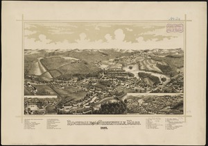
Rochdale and Greenville, Mass : 1887
7354.
Rochester, N.H : Gonic and East-Rochester, 1884
7355.
Rock Island-Frisco lines and Chicago & Eastern Illinois R.R : traverse the richest and most prosperous commonwealths in the Union
7356.
Rockland
7357.
Rock's illustrated map of London
7358.
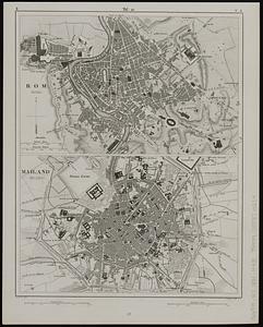
Rom (Roma) ; Mailand (Milano)
7359.
Roma, la capitale degli Stati Pontifici, fondata da Romolo e Remo verso vanno 754 prima di Cristo, e situato sul 41°53'54" di...
7360.
Roma, suburbio e dintorni
‹ Prev
Next ›
1
2
…
364
365
366
367
368
369
370
371
372
…
443
444