Toggle navigation
LMEC Home
Exhibitions
Georeferencing
Tools for Teachers
Collections
My Favorites
Sign Up / Log In
Search
Search the map portal
Map Collection
Map Collection
Map Sets
Search
Search
Search for
Search In
All Fields
Creator
Title
Subject
Place
Search All Digital Collections
Advanced Search
8893 Results
My Search
Start Over
More Like
commonwealth:3f463907j
Remove constraint More Like: commonwealth:3f463907j
Filter your Search
Place
North and Central America
6,132
United States
5,035
Massachusetts
2,183
Europe
1,392
Suffolk (county)
1,201
Boston
1,174
Canada
449
Asia
437
more
Place
»
Topic
Boston (Mass.)--Maps
747
United States--Maps
279
Massachusetts--Maps
233
Real property--Massachusetts--Boston--Maps
195
City planning--Massachusetts--Boston--Maps
156
Landowners--Massachusetts--Boston--Maps
142
New England--Maps
104
North America--Maps--Early works to 1800
103
more
Topic
»
Date
Date range begin
–
Date range end
Current results range from
1482
to
2023
View distribution
Creator
United States. Hydrographic Office
595
Boston Redevelopment Authority
162
O.H. Bailey & Co
148
Des Barres, Joseph F. W. (Joseph Frederick Wallet), 1722-1824
124
United States. Post Office Dept
120
Ptolemy, 2nd cent
100
Walling, Henry Francis, 1825-1888
95
Geological Survey (U.S.)
92
more
Creator
»
Format
Maps/Atlases
8,832
Manuscripts
219
Prints
56
Books
36
Objects/Artifacts
10
Drawings/Illustrations
8
Posters
5
Ephemera
1
Georeferenced
Yes
894
No
7,999
Collection
Norman B. Leventhal Map & Education Center Collection
8,715
Boston and New England Maps
2,390
Urban Maps
2,113
Maritime Charts and Atlases
1,083
American Revolutionary War-Era Maps
658
Boston Redevelopment Authority Collection
194
Mapping Boston Collection
22
Massachusetts Real Estate Atlases
22
more
Collection
»
Available to use
No known restrictions
8,657
Creative Commons license
73
Search Constraints
Sort by relevance
relevance
title
date (asc)
date (desc)
Number of results to display per page
20 per page
10
per page
20
per page
50
per page
100
per page
View results as:
grid view
map view
Search Results
41.
[Map of Boston and vicinity]
42.
Map of Boston and vicinity including the metropolitan park system
43.
Map of Boston and vicinity showing tracks operated by the Boston Elevated Railway Co., surface lines
44.
A map of Boston, county of Suffolk and the adjacent towns
45.
Map of Boston Harbor
46.
Map of Massachusetts
47.
Map of the city and vicinity of Boston Massachusetts
48.
Map of the city and vicinity of Boston, Massachusetts
49.
Map of the city of Boston and its environs
50.
Map of the metropolitan district of Boston, Massachusetts : showing the existing public reservations and such new open spaces...
51.
Map showing drives from the Walker-Gordon Laboratory, 203 Claredon St., Boston, to the Laboratory Farm in Wellesley
52.
Map showing the terminal facilities of Boston
53.
Motor routes that intersect the Bay Circuit
54.
New map of the vicinity of Boston, with the dates of settlement, population in 1840, and distance from the capital
55.
Plan of Boston and its vicinity showing the connection of the Grand Junction Rail Road with the Harbor and other Rail-roads
56.
Road map, drawn & engraved expressly for Road book of Boston & vicinity
57.
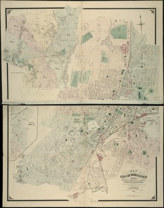
Atlas of the city of Worcester, Worcester County, Massachusetts
58.
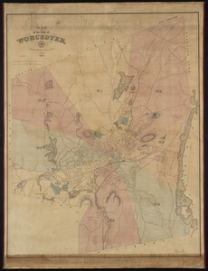
Map of the city of Worcester
59.
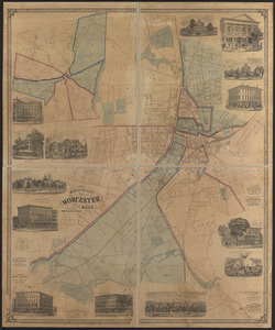
Map of the city of Worcester, Mass.
60.
Map of the city of Worcester, Mass
‹ Prev
Next ›
1
2
3
4
5
6
7
…
444
445
![[Map of Boston and vicinity]](https://bpldcassets.blob.core.windows.net/derivatives/images/commonwealth:wd376691q/image_thumbnail_300.jpg)