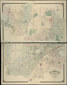
Atlas of the city of Worcester, Worcester County, Massachusetts
Item Information
- Title:
- Atlas of the city of Worcester, Worcester County, Massachusetts
- Cartographer:
- Beers, F. W. (Frederick W.)
- Publisher:
- F.W. Beers & Co.
- Name on Item:
-
from actual surveys by and under the direction of F.W. Beers ; assisted by Geo. P. Sanford and others
- Date:
-
1870
- Format:
-
Maps/Atlases
- Location:
-
Boston Public Library
Norman B. Leventhal Map & Education Center - Collection (local):
-
Norman B. Leventhal Map & Education Center Collection
- Subjects:
-
Worcester (Mass.)--Maps
Real property--Massachusetts--Worcester--Maps
Landowners--Massachusetts--Worcester--Maps
- Places:
-
MassachusettsWorcester (county)Worcester
- Extent:
- 1 atlas (33 leaves) : col. maps ; 41 cm.
- Terms of Use:
-
No known copyright restrictions.
No known restrictions on use.
- Publisher:
-
New York :
F.W. Beers & Co.
- Language:
-
English
- Notes:
-
"L.E. Neuman, eng. 95 Maiden Lane, N.Y." and "Lith. of Chas. Hart 99 Fulton St., N.Y."--title page.
"Worcester subscribers' business references."--[2] p., between leaves 8 and 9.
- Identifier:
-
06_01_018561
- Call #:
-
G1234.W9 B44 1870
- Barcode:
-
39999059016061