Toggle navigation
LMEC Home
Exhibitions
Georeferencing
Tools for Teachers
Collections
My Favorites
Sign Up / Log In
Search
Search the map portal
Map Collection
Map Collection
Map Sets
Search
Search
Search for
Search In
All Fields
Creator
Title
Subject
Place
Search All Digital Collections
Advanced Search
8592 Results
My Search
Start Over
More Like
commonwealth:3f4638304
Remove constraint More Like: commonwealth:3f4638304
Filter your Search
Place
North and Central America
5,878
United States
4,807
Massachusetts
2,052
Europe
1,359
Suffolk (county)
1,035
Boston
1,008
Canada
462
Asia
422
more
Place
»
Topic
Boston (Mass.)--Maps
578
United States--Maps
314
Real property--Massachusetts--Boston--Maps
174
Massachusetts--Maps
160
Landowners--Massachusetts--Boston--Maps
132
North America--Maps--Early works to 1800
103
New England--Maps
99
Europe--Maps
78
more
Topic
»
Date
Date range begin
–
Date range end
Current results range from
1482
to
2023
View distribution
Creator
United States. Hydrographic Office
594
O.H. Bailey & Co
148
Des Barres, Joseph F. W. (Joseph Frederick Wallet), 1722-1824
123
United States. Post Office Dept
120
Ptolemy, 2nd cent
100
Walling, Henry Francis, 1825-1888
94
Geological Survey (U.S.)
87
Jefferys, Thomas, -1771
85
more
Creator
»
Format
Maps/Atlases
8,533
Manuscripts
215
Prints
56
Books
36
Objects/Artifacts
10
Drawings/Illustrations
8
Posters
4
Georeferenced
Yes
871
No
7,721
Collection
Norman B. Leventhal Map & Education Center Collection
8,554
Boston and New England Maps
2,205
Urban Maps
1,937
Maritime Charts and Atlases
1,081
American Revolutionary War-Era Maps
651
Boston Redevelopment Authority Collection
88
American Antiquarian Society Collection
20
William L. Clements Library Collection
13
more
Collection
»
Available to use
No known restrictions
8,412
Creative Commons license
49
Search Constraints
Sort by relevance
relevance
title
date (asc)
date (desc)
Number of results to display per page
20 per page
10
per page
20
per page
50
per page
100
per page
View results as:
grid view
map view
Search Results
3261.
Kentuckey
3262.
Kentucky
3263.
Kentucky and Tennessee
3264.
Kentucky and Tennessee
3265.
Kentucky, reduced from Elihu Barker's large map
3266.
Keppell Harbour : Knowles Harbour ; Tangier Harbour ; Saunder's Harbour ; Deane Harbour
3267.
The Keystone group : a new railroad, post-office, township and district map of Pennsylvania, New Jersey, Delaware, Maryland,...
3268.
King Georges Group ; Aratica or Carlshoff Island
3269.
King Georges Group ; Aratica or Carlshoff Island
3270.
The kingdom of Poland and Great Dutchy of Lithuania with all their divisions
3271.
Kingdom of the Caliphs
3272.
The kingdoms of Spain and Portugal, divided into their great provinces
3273.
King's Bay ... : Lunenburg
3274.
Kingston, capitale de la Jamaique : bâtie par les Anglois en 1692
3275.
Kingston-Port-au-Prince
3276.
A kite view of Philadelphia and the Sesqui Centennial International Exposition
3277.
Klamath project, Oregon-California
3278.
Das königreich Griechenland mit den Ionischen Inseln
3279.
Königreich Griechenland nach den neuesten grenzbestimmungen
3280.
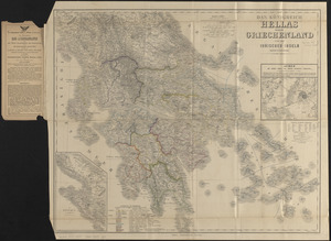
Das königreich Hellas oder Griechenland und die Ionischen Inseln (Ephtánisos)
‹ Prev
Next ›
1
2
…
160
161
162
163
164
165
166
167
168
…
429
430