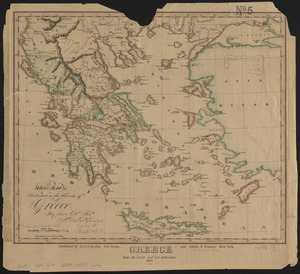
Das königreich Griechenland mit den Ionischen Inseln

Item Information
- Title:
- Das königreich Griechenland mit den Ionischen Inseln
- Cartographer:
- Ravenstein, Ludwig
- Publisher:
- Bibliographisches Institut Leipzig
- Name on Item:
-
L. Ravenstein dir. ; corr. II.
- Date:
-
[1870?–1879?]
- Format:
-
Maps/Atlases
- Location:
-
Boston Public Library
Norman B. Leventhal Map & Education Center - Collection (local):
-
Norman B. Leventhal Map & Education Center Collection
- Subjects:
-
Greece--Maps
- Places:
-
Greece
- Extent:
- 1 map : color ; 32 x 41 cm
- Terms of Use:
-
No known copyright restrictions.
No known restrictions on use.
- Publisher:
-
Leipzig :
Bibliographisches Institut in Leipzig
- Scale:
-
Scale 1:1,400,000
- Language:
-
German
- Notes:
-
Relief shown by hachures.
Prime meridians: Paris and Ferro.
Insets: Plan der gegend zwischen Athen u. dem Piraeos -- Plan von Athen.
In upper left: Meyer's hand-atlas.
- Identifier:
-
06_01_015061
- Call #:
-
G6810 1870 .R38
- Barcode:
-
39999085930079