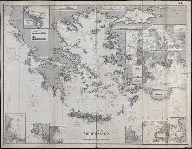
The Grecian archipelago, from the latest surveys
Item Information
- Title:
- The Grecian archipelago, from the latest surveys
- Cartographer:
- Hobbs, J. S. (John Stratton)
- Publisher:
- Wilson, Charles, active 1888
- Name on Item:
-
drawn by J.S. Hobbs, F.R.G.S. hydrographer
- Date:
-
1885
- Format:
-
Maps/Atlases
- Genre:
-
Nautical charts
- Location:
-
Boston Public Library
Norman B. Leventhal Map & Education Center - Collection (local):
-
Norman B. Leventhal Map & Education Center Collection
- Subjects:
-
Greece--Maps
Islands--Greece--Maps
Navigation--Greece
- Places:
-
Greece
- Extent:
- 1 map : hand colored ; 96 x 127 cm
- Terms of Use:
-
No known copyright restrictions.
No known restrictions on use.
- Publisher:
-
London :
Published by Chas. Wilson (late J.W. Norie & Wilson,) 156, Minories, E.
- Scale:
-
Scale approximately 1:900,000
- Language:
-
English
- Notes:
-
Relief shown by hachures and spot heights. Depths shown by soundings.
Includes 8 coastal views and 12 insets.
Insets: Corfu Road -- [Mouth of the Dardanelles] -- Kaloyeri Rocks -- Gulf and harbour of Smyrna -- [Sanjak Kalassi] -- Marmarice & Karaghatch -- Peninsula of Kara Bournou -- Gulf and harbour of Makry -- Town & port of Rhodes -- Syra Harbour -- Port Argostoli -- Zante Bay.
Lighthouses colored.
- Identifier:
-
06_01_015497
- Call #:
-
G6811.P5 1885 .H63
- Barcode:
-
39999085937694