Toggle navigation
LMEC Home
Exhibitions
Georeferencing
Tools for Teachers
Collections
My Favorites
Sign Up / Log In
Search
Search the map portal
Map Collection
Map Collection
Map Sets
Search
Search
Search for
Search In
All Fields
Creator
Title
Subject
Place
Search All Digital Collections
Advanced Search
255 Results
My Search
Start Over
More Like
commonwealth:3f462t67x
Remove constraint More Like: commonwealth:3f462t67x
Filter your Search
Place
North and Central America
209
United States
101
New England
99
Canada
51
Boston
48
Suffolk (county)
47
Boston Harbor
34
Nova Scotia
27
more
Place
»
Topic
New England--Maps--Early works to 1800
91
Nova Scotia--Maps--Early works to 1800
43
Coasts--Nova Scotia--Maps--Early works to 1800
30
Nautical charts--Nova Scotia--Early works to 1800
24
Middle Atlantic States--Maps--Early works to 1800
21
Boston (Mass.)--Maps
20
World maps--Early works to 1800
19
Boston Harbor (Mass.)--Maps--Early works to 1800
18
more
Topic
»
Date
Date range begin
–
Date range end
Current results range from
1493
to
1999
View distribution
Creator
Des Barres, Joseph F. W. (Joseph Frederick Wallet), 1722-1824
35
Bellin, Jacques Nicolas, 1703-1772
9
Jefferys, Thomas, d. 1771
8
Page, Thomas Hyde, Sir, 1746-1821
7
Southack, Cyprian, 1662-1745
6
United States Coast Survey
6
Dury, Andrew
5
Montrésor, John, 1736-1799
5
more
Creator
»
Format
Maps/Atlases
254
Manuscripts
1
Prints
1
Georeferenced
Yes
33
No
222
Collection
Norman B. Leventhal Map Center Collection
223
Mapping Boston Collection
139
American Revolutionary War-Era Maps
115
Boston and New England Maps
96
Maritime Charts and Atlases
71
Urban Maps
23
Sidney R. Knafel Map Collection at Phillips Academy
15
Richard H. Brown Revolutionary War Map Collection at Mount Vernon
7
more
Collection
»
Available to use
Creative Commons license
150
No known restrictions
87
Search Constraints
Sort by relevance
relevance
title
date (asc)
date (desc)
Number of results to display per page
20 per page
10
per page
20
per page
50
per page
100
per page
View results as:
grid view
map view
Search Results
21.
Noua Anglia, Nouum Belgium, et Virginia
22.
Nouvelle Hollande (à présent Nouvelle-York), Nouvelle-Angleterre, et une partie de la Virginie
23.
Nova Belgica et Anglia Nova
24.
Novi Belgii, Novaeque Angliae nec non partis Virginiae tabula
25.
Partie septentrionale des possessions Angloise en Amerique : pour servire d'intelligence à la guerre présente entre les...
26.
Pas-kaart vande zee kusten inde boght van Niew Engeland : tusschen de staaten Hoek en C. de Sable
27.
The south part of New England, as it planted this yeare, 1639
28.
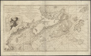
An actual survey of the sea coast from New York to the I. Cape Briton : with tables of the direct and thwart courses &...
29.
The American Pilot [title page]
30.
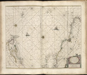
A chart of the sea coast of New Found Land, New Scotland, New England, New York, New Jersey, with Virginia and Maryland
31.
A chart of the West Indies from Cape Cod to the River Oronoque
32.
A new chart of the coast of New England, Nova Scotia, and the islands of St. Iohn, Cape Breton, Sable, the banks of St. Peters,...
33.
Pascaerte vande Vlaemsche, Soute, en Caribesche Eylanden, als mede Terra Nova, en de custen van Nova Francia, Nova Anglia, Nieu...
34.
Pascaerte vande Vlaemsche, Soute, en Caribesche Eylanden, als mede Terra Nova, en de custen van Nova Francia, Nova Anglia, Nieu...
35.
Barrington Bay
36.
Canso Harbor
37.
Carte de l'Acadie, Isle Royale, et Païs Voisins : pour servir à l'Histoire Générale des voyages
38.
Charlotte Bay
39.
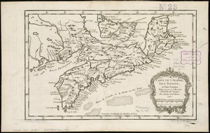
A chart of Nova Scotia
40.
Coast of Nova Scotia from Barrington Bay to Cape Blancherolte
‹ Prev
Next ›
1
2
3
4
5
6
…
12
13


![The American Pilot [title page]](https://bpldcassets.blob.core.windows.net/derivatives/images/commonwealth:3f462z36r/image_thumbnail_300.jpg)