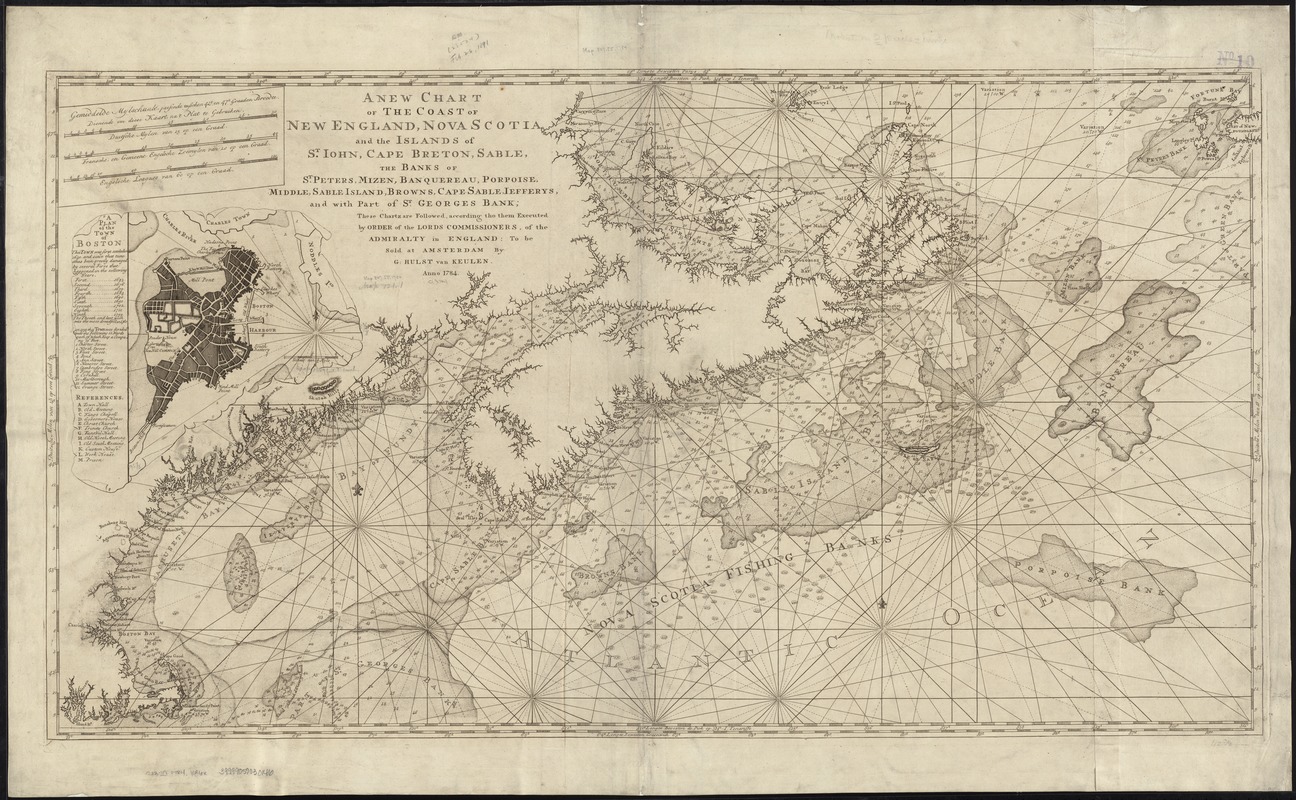
A new chart of the coast of New England, Nova Scotia, and the islands of St. Iohn, Cape Breton, Sable, the banks of St. Peters, Mizen, Banquereau, Porpoise, Middle, Sable Island, Browns, Cape Sable, Iefferys, and with part of St. Georges Bank
This map is also available in American Revolutionary Geographies Online (ARGO), a collections portal especially built for material relating to the American Revolutionary War Era. Visit ARGO to learn more about this item and explore the historical geography of North America in the late eighteenth century.
Item Information
- Title:
- A new chart of the coast of New England, Nova Scotia, and the islands of St. Iohn, Cape Breton, Sable, the banks of St. Peters, Mizen, Banquereau, Porpoise, Middle, Sable Island, Browns, Cape Sable, Iefferys, and with part of St. Georges Bank
- Title (alt.):
-
New chart of the coast of New England, Nova Scotia, and the islands of St. John, Cape Breton, Sable, the banks of St. Peters, Mizen, Banquereau, Porpoise, Middle, Sable Island, Browns, Cape Sable, Jefferys, and with part of St. Georges Bank
- Creator:
- Keulen, Gerard Hulst van, 1733-1801
- Date:
-
1784
- Format:
-
Maps/Atlases
- Location:
-
Boston Public Library
Norman B. Leventhal Map & Education Center - Collection (local):
-
Norman B. Leventhal Map & Education Center Collection
- Subjects:
-
Nautical charts--Atlantic Coast (North America)--Early works to 1800
Atlantic Coast (North America)--Maps--Early works to 1800
- Places:
-
North America (area)
- Extent:
- 1 map ; 58 x 108 cm.
- Terms of Use:
-
No known copyright restrictions.
No known restrictions on use.
- Publisher:
-
Amsterdam :
G. Hulst van Keulen
- Scale:
-
Scale ca. 1:1,200,000
- Language:
-
English
- Notes:
-
Depths shown by soundings.
"These chartz are followed, according tho them executed by order of the Lords Commissioners, of the Admiralty in England."
Inset: "A plan of the town of Boston."
Cataloging, conservation, and digitization made possible in part by The National Endowment for the Humanities: Exploring the human endeavor.
- Identifier:
-
06_01_007218
- Call #:
-
G3320 1784 .V36x
- Barcode:
-
39999059030146