Toggle navigation
LMEC Home
Exhibitions
Georeferencing
Tools for Teachers
Collections
My Favorites
Sign Up / Log In
Search
Search the map portal
Map Collection
Map Collection
Map Sets
Search
Search
Search for
Search In
All Fields
Creator
Title
Subject
Place
Search All Digital Collections
Advanced Search
265 Results
My Search
Start Over
More Like
commonwealth:3f462s24x
Remove constraint More Like: commonwealth:3f462s24x
Filter your Search
Place
North and Central America
156
United States
103
North America
63
World
63
South America
58
Mesoamerica
56
America
50
Boston
44
more
Place
»
Topic
World maps--Early works to 1800
76
America--Maps--Early works to 1800
72
Western Hemisphere--Maps--Early works to 1800
50
New England--Maps--Early works to 1800
23
Boston (Mass.)--Maps
20
Boston (Mass.)--History--Revolution, 1775-1783--Maps--Early works to 1800
16
Boston Harbor (Mass.)--Maps--Early works to 1800
13
North America--Maps--Early works to 1800
12
more
Topic
»
Date
Date range begin
–
Date range end
Current results range from
1488
to
1927
View distribution
Creator
Ortelius, Abraham, 1527-1598
7
Page, Thomas Hyde, Sir, 1746-1821
7
Speed, John, 1552?-1629
6
United States Coast Survey
6
L'Isle, Guillaume de, 1675-1726
5
Moll, Herman, d. 1732
5
Southack, Cyprian, 1662-1745
5
Bache, A. D. (Alexander Dallas), 1806-1867
4
more
Creator
»
Format
Maps/Atlases
264
Manuscripts
2
Prints
1
Georeferenced
Yes
31
No
234
Collection
Norman B. Leventhal Map Center Collection
238
Mapping Boston Collection
139
Boston and New England Maps
73
American Revolutionary War-Era Maps
48
Maritime Charts and Atlases
28
Urban Maps
23
Sidney R. Knafel Map Collection at Phillips Academy
21
New York Public Library Collection
4
more
Collection
»
Available to use
Creative Commons license
143
No known restrictions
101
Search Constraints
Sort by relevance
relevance
title
date (asc)
date (desc)
Number of results to display per page
20 per page
10
per page
20
per page
50
per page
100
per page
View results as:
grid view
map view
Search Results
41.
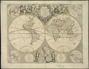
A new & correct map of the whole world : shewing ye situation of its principal parts. viz. the oceans, kingdoms, rivers, capes,...
42.
A new and accurat map of the world : drawne according to ye truest descriptions latest discoveries & best observations yt have...
43.
A new and accurat map of the world drawne according to ye truest descriptions latest discoveries & best observations yt have...
44.
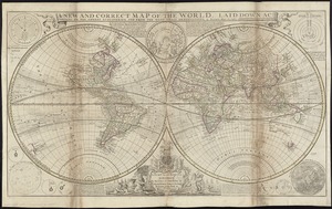
A new and correct map of the world, laid down according to the newest discoveries, and from the most exact observations
45.
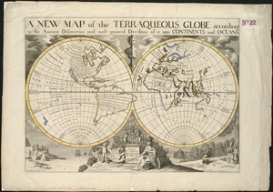
A new map of the terraqueous globe according to the ancient discoveries and most general divisions of it into continents and...
46.
A new map of the terraqueous globe according to the latest discoveries and most general divisions of it into continents and oceans
47.
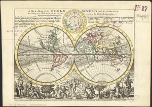
A new map of the whole world with the trade winds according to ye latest and most exact observations
48.
A new map of the world from the latest observations
49.
A new mapp of the world
50.
Nouus planiglobii terrestris per utrumque polum conspectus
51.
Nova, et integra universi orbis descriptio
52.
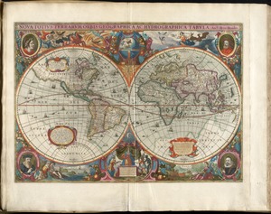
Nova totius terrarum orbis geographica ac hydrographica tabula
53.
Nova totius terrarum orbis geographica ac hydrographica tabula = Wahre Biltnüss des Gantzen Erden Kraÿses mit allen seinen...
54.
Nova totius terrarum orbis tabula
55.
Nova totivs terrarvm orbis geographica ac hydrographica tabvla
56.
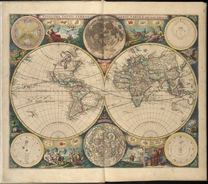
Novissima totius terrarum orbis tabula
57.
Orbis terrae compendiosa descriptio : quam ex magna universali Gerardi Mercatoris Domino Richardo Gartho, geographie ac...
58.
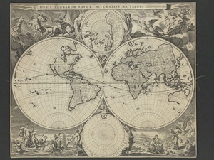
Orbis terrarum nova et accuratissima tabula
59.
Orbis terrarum nova et accuratissima tabula
60.
Orbis typus uniuersalis iuxta hydrographorum traditionem
‹ Prev
Next ›
1
2
3
4
5
6
7
…
13
14