Orbis terrarum nova et accuratissima tabula
Item Information
- Title:
- Orbis terrarum nova et accuratissima tabula
- Description:
-
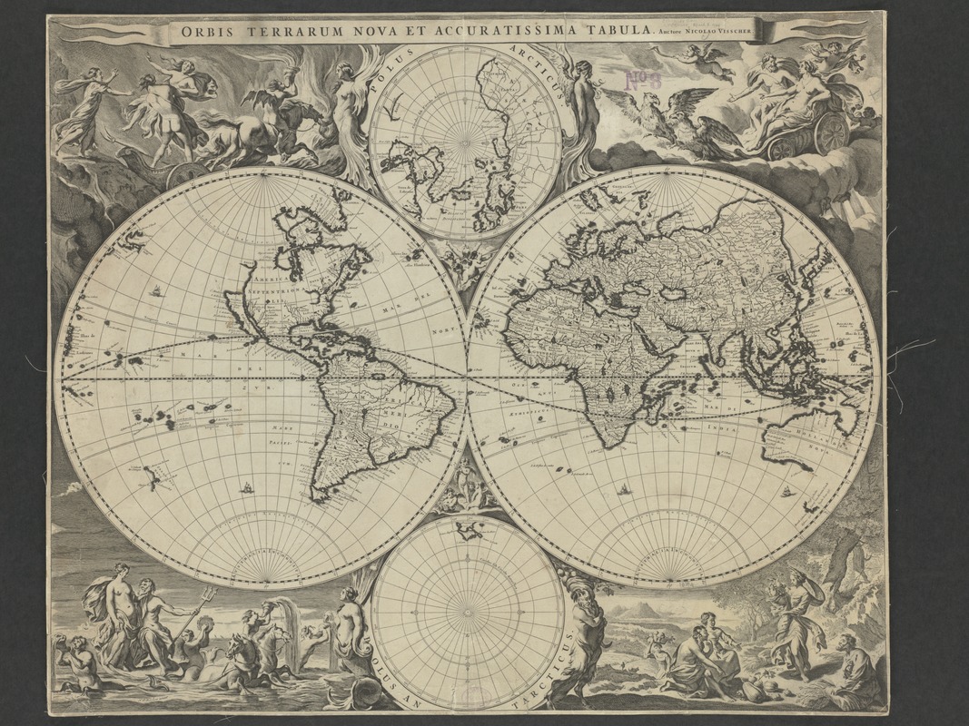
As a variation to earlier double hemisphere world maps, Visscher, a mid-17th-century Dutch cartographer, added two smaller spheres to his presentation, with each depicting the northern and southern polar regions. His map, also ornately decorated, first appeared in Jan Jansson's 1658 ''Novus Atlas''. The map was reused, unchanged, in later atlases compiled by the Visscher family and in composite atlases. Visscher's world map influenced other late 17th-century Dutch cartographers in the production of highly decorative world maps. The map's uniqueness and distinct attraction is its marginal decorations which were the work of artist Nicolaes Berchem. The artist created four dramatic scenes from classical mythology--the rape of Persephone amidst a flaming background, Zeus as he was carried across the heavens in an eagle-drawn chariot, Poseidon and his entourage emerging from the sea, and Demeter receiving the fruits of the land. These vignettes are also suggestive of the four basic elements. Geographically, the information presented on this map did not differ significantly from earlier Dutch maps. It continued the practice of showing California as an island, an interpretation that first appeared on English maps in the mid-1620s, and was quickly adopted by Dutch cartographers in the 1630s.
- Creator:
- Visscher, Nicolaes, 1649-1702
- Name on Item:
-
auctore Nicolao Visscher.
- Date:
-
[1690?]
- Format:
-
Maps/Atlases
- Location:
-
Boston Public Library
Norman B. Leventhal Map & Education Center - Collection (local):
-
Norman B. Leventhal Map & Education Center Collection
- Subjects:
-
World maps--Early works to 1800
- Places:
-
World
- Extent:
- 1 map ; 2 hemispheres each 28 cm. in diam., on sheet 50 x 62 cm.
- Terms of Use:
-
No known copyright restrictions.
No known restrictions on use.
- Publisher:
-
[Amsterdam?] :
Nicolao Visscher
- Scale:
-
Scale [ca. 1:80,000,000]. At equator
- Language:
-
Latin
- Notes:
-
Relief shown pictorially.
Includes ancillary maps of north polar region and south polar region and col. ill.
Exhibited in “Journeys of the Imagination,” at the Boston Public Library, Boston, MA, April - August 2006. MB (BRL)
- Identifier:
-
05_01_000209
- Call #:
-
G3200 1690 .V5
- Barcode:
-
39999052508023
- LCCN:
-
2006627252


