A new & correct map of the whole world : shewing ye situation of its principal parts. viz. the oceans, kingdoms, rivers, capes, ports, mountains, woods, trade-winds, monsoons, variation of ye compass, climate, &c. ; with the most remarkable tracks of the bold attempts which have been made to find out the northeast & northwest passages
Item Information
- Title:
- A new & correct map of the whole world : shewing ye situation of its principal parts. viz. the oceans, kingdoms, rivers, capes, ports, mountains, woods, trade-winds, monsoons, variation of ye compass, climate, &c. ; with the most remarkable tracks of the bold attempts which have been made to find out the northeast & northwest passages
- Title (alt.):
-
new & correct map of the whole world : shewing ye situation of its principal parts. viz. the seas, kingdoms, rivers, capes, ports, mountains, woods, trade-winds, monsoons, variation of ye compass, climate, &c
- Description:
-
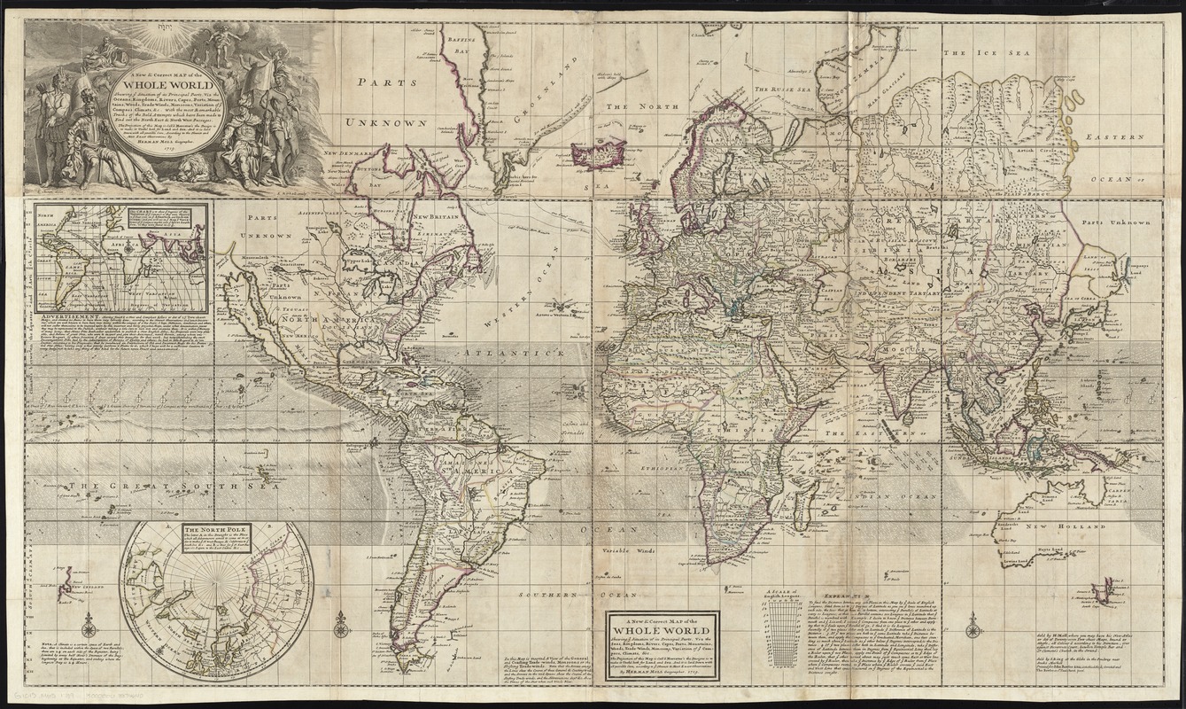
Regions and Seasons: London-based cartographer Herman Moll produced this world map for his atlas The World Described (1709-36) to document the numerous expeditions undertaken by English explorers searching for an ocean passage to Asia. In addition to notes on climate and weather events, Moll also included an early rendering of the trade winds in this map. Shown as small arrows and curving lines, Moll based his depiction on the first meteorological map produced by Edmund Halley in 1686. The seasonal trade winds were critical to efficient navigation of oceans in the 18th century.
- Creator:
- Moll, Herman, d. 1732
- Name on Item:
-
by Herman Moll, geographer ; L. Ckeron, delin. ; E. Kirkall, sculp.
- Date:
-
1719
- Format:
-
Maps/Atlases
- Location:
-
Boston Public Library
Norman B. Leventhal Map & Education Center - Collection (local):
-
Norman B. Leventhal Map & Education Center Collection
- Subjects:
-
World maps--Early works to 1800
Trade winds--Maps--Early works to 1800
- Places:
-
World
- Extent:
- 1 map on 2 sheets : hand. col., assembled ; 71 x 122 cm.
- Terms of Use:
-
No known copyright restrictions.
No known restrictions on use.
- Publisher:
-
[London] :
Sold by H. Moll ; Sold by I. King ; Printed for John Bowles & Son ... and Tho. Bowles
- Scale:
-
Scale [ca. 1:26,000,000] at equator ;
- Language:
-
English
- Notes:
-
World map showing trade winds, climate zones, magnetic variation, and exploration routes.
Title from illustrated cartouche; alternate title in box at lower center.
Relief shown pictorially.
Includes notes.
Insets: [World map] : this chart is to shew degrees of the variation of ye compas's as they were observ'd in ye year 1700 in ye Atlantick and Indian Ocean: and you will see in ye map & ye variations of ye compass markt over ye Great South Sea as they were found in 17 9/10 -- The North Pole.
Appears in Moll's The world described, [1709-1736], plate 2.
- Notes (exhibitions):
-
Exhibited: "Regions and Seasons: Mapping Climate through History" organized by the Norman B. Leventhal Map Center at the Boston Public Library, 2017.
- Identifier:
-
06_01_009658
- Call #:
-
G1015 .M65 1709
- Barcode:
-
30000003874640


