Toggle navigation
LMEC Home
Exhibitions
Georeferencing
Tools for Teachers
Collections
My Favorites
Sign Up / Log In
Search
Search the map portal
Map Collection
Map Collection
Map Sets
Search
Search
Search for
Search In
All Fields
Creator
Title
Subject
Place
Search All Digital Collections
Advanced Search
1046 Results
My Search
Start Over
More Like
commonwealth:2801s0605
Remove constraint More Like: commonwealth:2801s0605
Filter your Search
Place
North and Central America
1,042
United States
1,037
Suffolk (county)
1,022
Boston
1,021
Massachusetts
712
Roxbury
53
South End
45
Downtown Boston
40
more
Place
»
Topic
Boston (Mass.)--Maps
752
City planning--Massachusetts--Boston--Maps
366
Urban renewal--Massachusetts--Boston--Maps
234
Real property--Massachusetts--Boston--Maps
131
Land use--Massachusetts--Boston--Maps
99
Buildings--Massachusetts--Boston--Maps
86
Landowners--Massachusetts--Boston--Maps
76
Local transit--Massachusetts--Boston--Maps
57
more
Topic
»
Date
Date range begin
–
Date range end
Current results range from
1743
to
2023
View distribution
Creator
Boston Redevelopment Authority
354
Geo. H. Walker & Co
27
Boynton, George W., d. 1884
21
Sampson, Davenport & Co
21
Sampson, Murdock & Co
20
Bromley, George Washington
18
Bromley, Walter Scott
17
Lufkin, Richard F. (Richard Friend)
17
more
Creator
»
Format
Maps/Atlases
1,046
Manuscripts
9
Prints
1
Georeferenced
Yes
98
No
948
Collection
Boston and New England Maps
866
Urban Maps
768
Norman B. Leventhal Map & Education Center Collection
625
Boston Redevelopment Authority Collection
403
American Revolutionary War-Era Maps
25
Mapping Boston Collection
20
Massachusetts Real Estate Atlases
12
William L. Clements Library Collection
10
more
Collection
»
Available to use
No known restrictions
978
Creative Commons license
34
Search Constraints
Sort by relevance
relevance
title
date (asc)
date (desc)
Number of results to display per page
20 per page
10
per page
20
per page
50
per page
100
per page
View results as:
grid view
map view
Search Results
341.
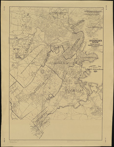
Map of Boston and vicinity showing tracks operated by the Boston Elevated Railway Co., surface lines
342.
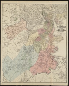
Map of Boston (as it should be) and the country adjacent, with proposed harbor improvements, etc
343.
Map of Boston Common : with surrounding streets & adjacent parts of Beacon Hill
344.
Map of Boston Common and Public Garden
345.
Map of Boston, comprising the whole city, with the new boundaries of the wards
346.
A map of Boston, county of Suffolk and the adjacent towns
347.
Map of Boston for 1874
348.
Map of Boston, for 1874
349.
Map of Boston, for 1875
350.
Map of Boston, for 1876
351.
Map of Boston, for 1877
352.
Map of Boston, for 1878
353.
Map of Boston, for 1879
354.
Map of Boston for 1880
355.
Map of Boston, for 1881
356.
Map of Boston, for 1881
357.
Map of Boston, for 1882
358.
Map of Boston, for 1883
359.
Map of Boston, for 1883
360.
Map of Boston, for 1884
‹ Prev
Next ›
1
2
…
14
15
16
17
18
19
20
21
22
…
52
53