Toggle navigation
LMEC Home
Exhibitions
Georeferencing
Tools for Teachers
Collections
My Favorites
Sign Up / Log In
Search
Search the map portal
Map Collection
Map Collection
Map Sets
Search
Search
Search for
Search In
All Fields
Creator
Title
Subject
Place
Search All Digital Collections
Advanced Search
8747 Results
My Search
Start Over
More Like
commonwealth:0r96fp66r
Remove constraint More Like: commonwealth:0r96fp66r
Filter your Search
Place
North and Central America
5,954
United States
4,850
Massachusetts
2,079
Europe
1,396
Suffolk (county)
1,047
Boston
1,019
Canada
449
Asia
438
more
Place
»
Topic
Boston (Mass.)--Maps
586
United States--Maps
284
Real property--Massachusetts--Boston--Maps
175
Massachusetts--Maps
162
Landowners--Massachusetts--Boston--Maps
133
North America--Maps--Early works to 1800
105
New England--Maps
102
North America--Maps
85
more
Topic
»
Date
Date range begin
–
Date range end
Current results range from
1482
to
2023
View distribution
Creator
United States. Hydrographic Office
595
O.H. Bailey & Co
148
Des Barres, Joseph F. W. (Joseph Frederick Wallet), 1722-1824
123
United States. Post Office Dept
120
Ptolemy, 2nd cent
100
Walling, Henry Francis, 1825-1888
94
Jefferys, Thomas, -1771
87
Geological Survey (U.S.)
86
more
Creator
»
Format
Maps/Atlases
8,687
Manuscripts
215
Prints
56
Books
36
Objects/Artifacts
10
Drawings/Illustrations
8
Posters
5
Georeferenced
Yes
872
No
7,875
Collection
Norman B. Leventhal Map & Education Center Collection
8,696
Boston and New England Maps
2,233
Urban Maps
2,023
Maritime Charts and Atlases
1,083
American Revolutionary War-Era Maps
667
Boston Redevelopment Authority Collection
87
American Antiquarian Society Collection
17
William L. Clements Library Collection
14
more
Collection
»
Available to use
No known restrictions
8,554
Creative Commons license
58
Search Constraints
Sort by relevance
relevance
title
date (asc)
date (desc)
Number of results to display per page
20 per page
10
per page
20
per page
50
per page
100
per page
View results as:
grid view
map view
Search Results
401.
Asiæ quæ vulgo minor dicitur et Syriæ tabula geographica : quantum per subsidia licuit elaborata, opere, si quod aliud in...
402.
Asiatische Türkei
403.
L'Asie antérieure : d'après le texte de la Nouvelle Géographie Universelle et d'autres documents récents
404.
Asien
405.
Ask Shell!
406.
Aspect général de Paris
407.
Aspect général de Rome
408.
Assiniboia
409.
An astronomical chart or diagram, in which the structure of the solar system is exhibited at one view
410.
At the request of the recorder Thomas Jones Esqr. chairman, & the other gentlemen of the committee, I have surveyed the farm...
411.
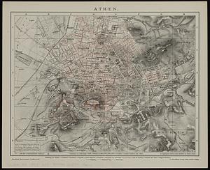
Athen
412.
Athens
413.
Athol, Mass : 1887
414.
Atlantic Neptune [front matter]
415.
Atlantic Neptune [front matter]
416.
Atlantic Ocean, Azores or Western Isles
417.
Atlantic Ocean, Bay of Biscay, ports on the north coast of Spain : from Spanish government surveys, corrected to 1876
418.
Atlantic Ocean, n.w. coast of Africa, Mogador or Zuerah Harbor : from British and French surveys in 1835 & 1852; the south...
419.
Atlas of Abington and Rockland, Massachusetts : from recent and actual surveys & records
420.
Atlas of Attleboro' Town, Massachusetts
‹ Prev
Next ›
1
2
…
17
18
19
20
21
22
23
24
25
…
437
438


![Atlantic Neptune [front matter]](https://bpldcassets.blob.core.windows.net/derivatives/images/commonwealth:3f462w98b/image_thumbnail_300.jpg)
![Atlantic Neptune [front matter]](https://bpldcassets.blob.core.windows.net/derivatives/images/commonwealth:3f462x58k/image_thumbnail_300.jpg)


