Toggle navigation
LMEC Home
Exhibitions
Georeferencing
Tools for Teachers
Collections
My Favorites
Sign Up / Log In
Search
Search the map portal
Map Collection
Map Collection
Map Sets
Search
Search
Search for
Search In
All Fields
Creator
Title
Subject
Place
Search All Digital Collections
Advanced Search
8695 Results
My Search
Start Over
More Like
commonwealth:0r96fp272
Remove constraint More Like: commonwealth:0r96fp272
Filter your Search
Place
North and Central America
5,926
United States
4,849
Massachusetts
2,068
Europe
1,392
Suffolk (county)
1,041
Boston
1,014
Canada
463
Asia
437
more
Place
»
Topic
Boston (Mass.)--Maps
582
United States--Maps
327
Real property--Massachusetts--Boston--Maps
175
Massachusetts--Maps
161
Landowners--Massachusetts--Boston--Maps
133
North America--Maps--Early works to 1800
103
New England--Maps
101
Europe--Maps
79
more
Topic
»
Date
Date range begin
–
Date range end
Current results range from
1482
to
2023
View distribution
Creator
United States. Hydrographic Office
595
O.H. Bailey & Co
148
Des Barres, Joseph F. W. (Joseph Frederick Wallet), 1722-1824
123
United States. Post Office Dept
120
Ptolemy, 2nd cent
100
Walling, Henry Francis, 1825-1888
94
Geological Survey (U.S.)
87
Jefferys, Thomas, -1771
85
more
Creator
»
Format
Maps/Atlases
8,635
Manuscripts
215
Prints
56
Books
36
Objects/Artifacts
10
Drawings/Illustrations
8
Posters
5
Georeferenced
Yes
871
No
7,824
Collection
Norman B. Leventhal Map & Education Center Collection
8,652
Boston and New England Maps
2,221
Urban Maps
1,992
Maritime Charts and Atlases
1,083
American Revolutionary War-Era Maps
656
Boston Redevelopment Authority Collection
87
American Antiquarian Society Collection
20
William L. Clements Library Collection
13
more
Collection
»
Available to use
No known restrictions
8,508
Creative Commons license
50
Search Constraints
Sort by relevance
relevance
title
date (asc)
date (desc)
Number of results to display per page
20 per page
10
per page
20
per page
50
per page
100
per page
View results as:
grid view
map view
Search Results
21.
Military map of the United States
22.
Military map of the United States of America showing location of all forces in training
23.
A new map of the United States of America
24.
Rail road map of the southern states shewing the southern & southwestern railway connections with Philadelphia
25.
Railroad distance map of the United States, Mexico & Canada
26.
Rand McNally & Co's new railroad and county map of the United States and Dominion of Canada
27.
Rock Island-Frisco lines and Chicago & Eastern Illinois R.R : traverse the richest and most prosperous commonwealths in the Union
28.
Skeleton map of rail-roads between Cape Canso and St. Louis
29.
Skeleton map showing the rail roads completed and in progress in the United States and their connection as proposed with the...
30.
The southwestern railroad system United States and Mexico
31.
Trans-continental map : showing the main lines and proposed extensions of the various trans-continental railroad systems of the...
32.
Traveler's rail road map of the United States to accompany "Boston to Washington" Riverside Series Centennial Guides
33.
Venango railroad and its connections, air line from New York to Cleveland, Toledo & Chicago
34.
Great Northern Railway and proprietary lines
35.
Map of routes for a Pacific railroad
36.
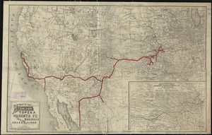
Map of the Atchison Topeka and Santa Fe Railroad and its leased lines
37.
Map seventh division railway mail service
38.
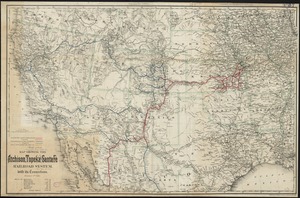
Map showing the Atchison, Topeka and Santa Fe railroad system : with its connections
39.
Colton's new railroad & county map of the United States, the Canadas &c
40.
How the public domain has been squandered, map showing the 139,403,026 acres of the people's land - equal to 871,268 farms of...
‹ Prev
Next ›
1
2
3
4
5
6
…
434
435