Toggle navigation
LMEC Home
Exhibitions
Georeferencing
Tools for Teachers
Collections
My Favorites
Sign Up / Log In
Search
Search the map portal
Map Collection
Map Collection
Map Sets
Search
Search
Search for
Search In
All Fields
Creator
Title
Subject
Place
Search All Digital Collections
Advanced Search
8795 Results
My Search
Start Over
More Like
commonwealth:0r96fn97j
Remove constraint More Like: commonwealth:0r96fn97j
Filter your Search
Place
North and Central America
6,023
United States
4,924
Massachusetts
2,151
Europe
1,396
Suffolk (county)
1,048
Boston
1,020
Canada
451
Asia
438
more
Place
»
Topic
Boston (Mass.)--Maps
590
United States--Maps
282
Massachusetts--Maps
235
Real property--Massachusetts--Boston--Maps
175
Landowners--Massachusetts--Boston--Maps
133
New England--Maps
104
North America--Maps--Early works to 1800
103
Manuscript maps
84
more
Topic
»
Date
Date range begin
–
Date range end
Current results range from
1482
to
2023
View distribution
Creator
United States. Hydrographic Office
595
O.H. Bailey & Co
148
Des Barres, Joseph F. W. (Joseph Frederick Wallet), 1722-1824
123
United States. Post Office Dept
120
Ptolemy, 2nd cent
100
Walling, Henry Francis, 1825-1888
95
Geological Survey (U.S.)
92
Jefferys, Thomas, -1771
85
more
Creator
»
Format
Maps/Atlases
8,734
Manuscripts
243
Prints
56
Books
36
Objects/Artifacts
10
Drawings/Illustrations
8
Posters
5
Ephemera
1
Georeferenced
Yes
878
No
7,917
Collection
Norman B. Leventhal Map & Education Center Collection
8,742
Boston and New England Maps
2,279
Urban Maps
2,024
Maritime Charts and Atlases
1,083
American Revolutionary War-Era Maps
659
Boston Redevelopment Authority Collection
90
Library of Congress Collection
22
Applied Geographics, Inc. Records
20
more
Collection
»
Available to use
No known restrictions
8,597
Creative Commons license
76
Search Constraints
Sort by relevance
relevance
title
date (asc)
date (desc)
Number of results to display per page
20 per page
10
per page
20
per page
50
per page
100
per page
View results as:
grid view
map view
Search Results
241.
Sketch of the harbour of Charles Town
242.
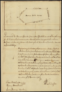
Survey of land for Richard Stephenson in Frederick County; attested by Robert Worthington, Henry Bradshaw and Lewis Thomas : recto
243.
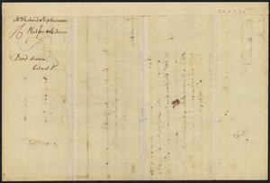
Survey of land for Richard Stephenson in Frederick County; attested by Robert Worthington, Henry Bradshaw and Lewis Thomas : verso
244.
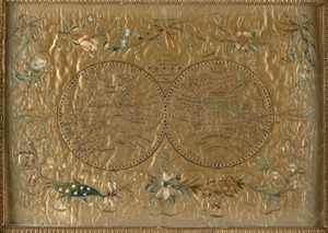
The world
245.
The world with all the modern discoveries
246.
An accurate map of the commonwealth of Massachusetts exclusive of the district of Maine compiled pursuant to an act of the...
247.
An accurate map of the commonwealth of Massachusetts exclusive of the district of Maine compiled pursuant to an act of the...
248.
Atlas of Massachusetts
249.
Atlas of Massachusetts
250.
Commonwealth of Massachusetts U.S. congressional districts
251.
DFWELE land showing 1985-1990 acquisitions
252.
Eastern encephalitis risk area
253.
EOEA MassGIS geographic information system transition document : The EOEA geographic information system: MassGIS
254.
EOEA wide area network
255.
Executive Office of Environmental Affairs location of offices
256.
Explorer's map & directory of the New England Coast : New London, Connecticut, to Passamaquoddy Bay, Canada : a comprehensive...
257.
Flynt Jenkins sold to Taylor Foster &c plans 1778
258.
General plan of the MWRA/MDC water system
259.
Geographical, historical, and statistical map of Massachusetts
260.
Geological map of Massachusetts
‹ Prev
Next ›
1
2
…
9
10
11
12
13
14
15
16
17
…
439
440