Toggle navigation
LMEC Home
Exhibitions
Georeferencing
Tools for Teachers
Collections
My Favorites
Sign Up / Log In
Search
Search the map portal
Map Collection
Map Collection
Map Sets
Search
Search
Search for
Search In
All Fields
Creator
Title
Subject
Place
Search All Digital Collections
Advanced Search
8696 Results
My Search
Start Over
More Like
commonwealth:0r96fn08n
Remove constraint More Like: commonwealth:0r96fn08n
Filter your Search
Place
North and Central America
5,926
United States
4,844
Massachusetts
2,079
Europe
1,396
Suffolk (county)
1,046
Boston
1,019
Canada
449
Asia
439
more
Place
»
Topic
Boston (Mass.)--Maps
586
United States--Maps
282
Real property--Massachusetts--Boston--Maps
175
Massachusetts--Maps
162
Landowners--Massachusetts--Boston--Maps
133
North America--Maps--Early works to 1800
103
New England--Maps
102
Europe--Maps
79
more
Topic
»
Date
Date range begin
–
Date range end
Current results range from
1482
to
2023
View distribution
Creator
United States. Hydrographic Office
595
O.H. Bailey & Co
148
Des Barres, Joseph F. W. (Joseph Frederick Wallet), 1722-1824
123
United States. Post Office Dept
120
Ptolemy, 2nd cent
100
Walling, Henry Francis, 1825-1888
94
Geological Survey (U.S.)
86
Jefferys, Thomas, -1771
85
more
Creator
»
Format
Maps/Atlases
8,636
Manuscripts
215
Prints
56
Books
36
Objects/Artifacts
10
Drawings/Illustrations
8
Posters
5
Georeferenced
Yes
870
No
7,826
Collection
Norman B. Leventhal Map & Education Center Collection
8,695
Boston and New England Maps
2,233
Urban Maps
2,023
Maritime Charts and Atlases
1,083
American Revolutionary War-Era Maps
616
Boston Redevelopment Authority Collection
87
Sidney R. Knafel Map Collection at Phillips Academy
1
Available to use
No known restrictions
8,553
Creative Commons license
47
Search Constraints
Sort by relevance
relevance
title
date (asc)
date (desc)
Number of results to display per page
20 per page
10
per page
20
per page
50
per page
100
per page
View results as:
grid view
map view
Search Results
1.
Saishin ōshū daichizu
2.
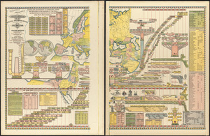
Genealogical, chronological and geographical chart embracing Biblical and profane history of ancient times from Adam to Christ
3.
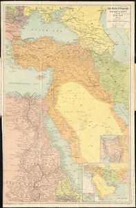
Eastern Mediterranean
4.
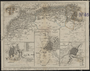
Marocco, Algier und Tunis
5.
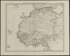
Mittel- und Nord-Africa, westl. theil
6.
USAF cloth chart, Western Mediterranean
7.
Asiatische Türkei
8.
L'Asie antérieure : d'après le texte de la Nouvelle Géographie Universelle et d'autres documents récents
9.
Commercial map of the Near East
10.
The Daily Telegraph war map of Egypt and the Near East (No. 6)
11.
Danube to India
12.
Griechenland zur zeit des Peloponnesischen Krieges, nach den glaubwürdigsten geschichtsschreibern
13.
Guerre d'orient, Balkans, Asie Mineure, Perse
14.
A map of those countries in which the apostles travelled : in propagating Christianity
15.
A map of Turkey in Asia
16.
Middle East, oil and gas : Middle East
17.
Near East Relief
18.
An accurate map of Europe from the best authorities
19.
Angling in troubled waters = der fischfang im truben = la peche en eau trouble = la pesca nelle acque turbes : a serio-comic...
20.
Bacon's large scale shilling map of seat of war from Paris to Berlin, and the Baltic
‹ Prev
Next ›
1
2
3
4
5
…
434
435