Toggle navigation
LMEC Home
Exhibitions
Georeferencing
Tools for Teachers
Collections
My Favorites
Sign Up / Log In
Search
Search the map portal
Map Collection
Map Collection
Map Sets
Search
Search
Search for
Search In
All Fields
Creator
Title
Subject
Place
Search All Digital Collections
Advanced Search
8968 Results
My Search
Start Over
More Like
commonwealth:02873q119
Remove constraint More Like: commonwealth:02873q119
Filter your Search
Place
North and Central America
6,199
United States
5,115
Massachusetts
2,158
Europe
1,396
Suffolk (county)
1,314
Boston
1,287
Canada
449
Asia
438
more
Place
»
Topic
Boston (Mass.)--Maps
752
United States--Maps
282
Real property--Massachusetts--Boston--Maps
253
City planning--Massachusetts--Boston--Maps
235
Landowners--Massachusetts--Boston--Maps
170
Massachusetts--Maps
166
Urban renewal--Massachusetts--Boston--Maps
135
Buildings--Massachusetts--Boston--Maps
125
more
Topic
»
Date
Date range begin
–
Date range end
Current results range from
1482
to
2023
View distribution
Creator
United States. Hydrographic Office
595
Boston Redevelopment Authority
236
O.H. Bailey & Co
148
Des Barres, Joseph F. W. (Joseph Frederick Wallet), 1722-1824
124
United States. Post Office Dept
120
Ptolemy, 2nd cent
100
Walling, Henry Francis, 1825-1888
94
Geological Survey (U.S.)
87
more
Creator
»
Format
Maps/Atlases
8,908
Manuscripts
215
Prints
56
Books
36
Objects/Artifacts
10
Drawings/Illustrations
8
Posters
5
Georeferenced
Yes
885
No
8,083
Collection
Norman B. Leventhal Map & Education Center Collection
8,724
Boston and New England Maps
2,438
Urban Maps
2,222
Maritime Charts and Atlases
1,083
American Revolutionary War-Era Maps
638
Boston Redevelopment Authority Collection
271
Massachusetts Real Estate Atlases
38
Mapping Boston Collection
20
more
Collection
»
Available to use
No known restrictions
8,745
Creative Commons license
70
Search Constraints
Sort by relevance
relevance
title
date (asc)
date (desc)
Number of results to display per page
20 per page
10
per page
20
per page
50
per page
100
per page
View results as:
grid view
map view
Search Results
1501.
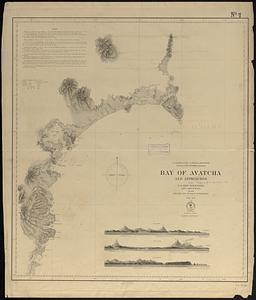
Bay of Avatcha and approaches
1502.
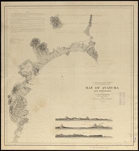
Bay of Avatcha and approaches
1503.
Bay of Chaleurs
1504.
Bay of Massefao, island of Tutuila ; Bay of Fagaitui, island of Tutuila ; Sketch of Aluau Bay, 1839 ; Sketch of Anuu Island, 1839
1505.
Bay of Massefao, island of Tutuila ; Bay of Fagaitui, island of Tutuila ; Sketch of Aluau Bay, 1839 ; Tutuila Isld., approaches...
1506.
[Bay of Seven Islands]
1507.
Bay State Street Ry. Co's lines and connections
1508.
The Bear Garden, the Globe Theatre
1509.
La Beauce
1510.
Beaufort Harbor and coast line between Charleston S.C. and Savanna Ga : with 5 mile distance lines in circles round Beaufort...
1511.
Becket
1512.
Becket, Mass
1513.
Beddington, Surrey : plan of Croydon sewage farm
1514.
Bedford Co., Pa
1515.
Bedford irrigation farm
1516.
Begin with sense, of ev'ry art the soul, parts answ'ring parts shall slide into a whole
1517.
The beginnings of ancient China, 1900-1300 B.C.
1518.
Behring's Sea and Arctic Ocean : from surveys of the U.S. North Pacific Surveying Expedition in 1855, Commander John Rodgers,...
1519.
Being a cartograph of Ohio : the oldest state west of the thirteen original colonies; now the fourth state in the Union in...
1520.
Being a map of the United States in the year 1831 when the Country Gentleman first made its appearance as the Genesee Farmer
‹ Prev
Next ›
1
2
…
72
73
74
75
76
77
78
79
80
…
448
449


![[Bay of Seven Islands]](https://bpldcassets.blob.core.windows.net/derivatives/images/commonwealth:7h149v48t/image_thumbnail_300.jpg)


